Tue, Jun 28, 2005
Mission Slated For 2007 or 2008
 When India launches its first-ever
unmanned moon mission, it will carry payloads for the European
Space Agency and NASA, according to the country's space agency.
When India launches its first-ever
unmanned moon mission, it will carry payloads for the European
Space Agency and NASA, according to the country's space agency.
“The payload from ESA that would weigh 30 kg will include
a multi-spectrometer and a particle detector,” Indian
Satellite Research Organization (ISRO) chairman Dr. G. Madhavan
Nair told reporters at an international conferences on Planetary
Exploration and Space Law. He was speaking in Bangalore, India.
“ISRO has already received a number of proposals from
international agencies including NASA. Deliberations are on and the
payload will be finalized shortly,” he said.
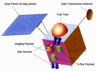
The ESA will contribute to the mission:
- A low energy (0.5-10 keV) X-ray spectrometer called Chandrayaan
Imaging X-Ray Spectrometer from Rutherford Appleton Laboratory, UK,
to measure elemental abundance distributed over the lunar surface
using X-ray fluorescence technique. It will also include X-ray
solar monitor to record the incident solar X-ray flux.
- Near Infra-Red (IR) Spectrometer from Max Planck Institute of
Aeronomie, Germany, to detect and measure lunar mineral
abundances.
- Sub keV Atom Reflecting Analyzer from Swedish Institute of
Space Physics, developed in collaboration with India, to measure
volatiles generated due to solar wind impacting on lunar surface
and determine the surface magnetic field anomalies.
- Europe will also contribute to the Indian experiment, namely,
High Energy X-ray Spectrometer.
The European instruments will complement the following main
Indian experiments on Chandrayaan-1:
- Terrain Mapping Camera with stereo imaging capability operating
in panchromatic band with 5 meter spatial resolution and 20 km
swath.
- A Hyper-Spectral Imager operating in 400-900 nm band with a
spectral resolution of 15 nm, a spatial resolution of 80 meter and
20 km swath.
- A Lunar Laser Ranging Instrument with a vertical resolution of
better than 5 meter.
- A High Energy X-ray (10-250 keV) spectrometer with a footprint
of 20 km to detect radio nuclei.
- In addition, an Impact Probe has been included in the mission
for proving technological elements required for future landing
missions.
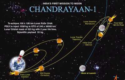
Chandrayaan-1 is planned for launch by 2007-08 on board India's
Polar Satellite Launch Vehicle. The 525 kg satellite will be placed
in 100 km polar orbit around the moon and it will have a life time
of two years.
More News
Also: Aerox 'Cylinder Sentinel', Annual TBM Reunion, Hubble Pause, Utah AAM A combined Spanish-Portuguese aerobatic demo team suffered a fatality at the Beja AirShow, when one of t>[...]
From 2019 (YouTube Version): Hartzell Propeller Secures STC For King Air Propellers Hartzell Propeller has secured an FAA Type Certificate for a new five-blade carbon fiber propell>[...]
"Starship’s third flight test made tremendous strides towards a future of rapidly reliable reusable rockets. The test completed several exciting firsts, including the first S>[...]
Aero Linx: Utah Back Country Pilots Association (UBCP) We hope to promote flying in Utah, and we welcome you to our state. We recognize the inherent hazards and risk involved in ba>[...]
Maximum Authorized Altitude A published altitude representing the maximum usable altitude or flight level for an airspace structure or route segment. It is the highest altitude on >[...]
 Airborne 06.05.24: Yakstars Midair, Electra eSTOL Test, Space Tour No-Go