Honeywell's Popular Handheld Now Available For Helicopters | Aero-News Network
Aero-News Network
RSS icon RSS feed
podcast icon MP3 podcast
Subscribe Aero-News e-mail Newsletter Subscribe

Airborne Unlimited -- Most Recent Daily Episodes

Episode Date

Airborne-Monday

Airborne-Tuesday

Airborne-Wednesday Airborne-Thursday

Airborne-Friday

Airborne On YouTube

Airborne-Unlimited-04.22.24

Airborne-Unlimited-04.16.24

Airborne-FlightTraining-04.17.24 Airborne-AffordableFlyers-04.18.24

Airborne-Unlimited-04.19.24

Join Us At 0900ET, Friday, 4/10, for the LIVE Morning Brief.
Watch It LIVE at
www.airborne-live.net

Tue, Feb 23, 2010

Honeywell's Popular Handheld Now Available For Helicopters

Bendix/King By Honeywell AV8OR Provides Portable Weather, Traffic and GPS

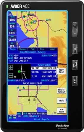
Honeywell announced Sunday at Heli-Expo 2010 that the AV8OR handheld Global Positioning System (GPS) is now available for helicopter operators.

"The AV8OR is a terrific addition to any helicopter, providing situational awareness of weather, terrain, traffic and airspace for very little cost," said Chad Cundiff, vice president, Crew Interface and Displays, Honeywell Aerospace. "For about $800, helicopter pilots get moving-map navigation with terrain awareness, which they can use on the ground or in the air, making every trip simple from door -- to air -- to door. The unit can also wirelessly interface to traffic and weather information."

The AV8OR is a portable touch-screen GPS for use in the car or in the air, with real-time weather capability, moving-map navigation and video-in capability. Its large 4.3-inch screen can display weather, from Honeywell's KDR 610 or the WxWorx portable receiver, and traffic from Zaon Flight Systems' XRX portable traffic receiver. The moving map display incorporates helicopter symbology, low altitude helicopter routes, helipads and controlled airspace.

The navigation database includes terrain shading and a SmartProfile view, enabling operators to see the terrain in the flight path of the helicopter.

With a $99 a year subscription, AV8OR offer daily updates on fuel pricing through Flight Guide, as well as on-field services, restaurants, taxi services and hotels. A dedicated online customer center provides operators with simple software updating capability.

The AV8OR is the first touch-screen handheld device developed for both aviation and automotive use, the first airway planner, the first to have multimedia capability and the first to have a Bluetooth phone interface -- all in one device.

FMI: www.honeywell.com

Advertisement

More News

ANN's Daily Aero-Term (04.26.24): DETRESFA (Distress Phrase)

DETRESFA (Distress Phrase) The code word used to designate an emergency phase wherein there is reasonable certainty that an aircraft and its occupants are threatened by grave and i>[...]

ANN's Daily Aero-Linx (04.26.24)

Aero Linx: The International Association of Missionary Aviation (IAMA) The International Association of Missionary Aviation (IAMA) is comprised of Mission organizations, flight sch>[...]

Airborne 04.22.24: Rotor X Worsens, Airport Fees 4 FNB?, USMC Drone Pilot

Also: EP Systems' Battery, Boeing SAF, Repeat TBM 960 Order, Japan Coast Guard H225 Buy Despite nearly 100 complaints totaling millions of dollars of potential fraud, combined with>[...]

Airborne 04.24.24: INTEGRAL E, Elixir USA, M700 RVSM

Also: Viasat-uAvionix, UL94 Fuel Investigation, AF Materiel Command, NTSB Safety Alert Norges Luftsportforbund chose Aura Aero's little 2-seater in electric trim for their next gli>[...]

Airborne-NextGen 04.23.24: UAVOS UVH 170, magni650 Engine, World eVTOL Directory

Also: Moya Delivery Drone, USMC Drone Pilot, Inversion RAY Reentry Vehicle, RapidFlight UAVOS has recently achieved a significant milestone in public safety and emergency services >[...]

blog comments powered by Disqus


Advertisement

Advertisement

Podcasts

Advertisement

© 2007 - 2024 Web Development & Design by Pauli Systems, LC