Updated Version Allows Overlays On Moving Map Page
Garmin has released an updated version of the Garmin Pilot app for the iPad and iPhone that incorporates the display of both terrain and obstacles on Garmin’s dynamic navigation maps, VFR Sectionals, IFR high and low en-route charts. The terrain and obstacle overlays also include visual alerting of potential hazards and projected impact points.
“We continue to expand on our safety enhancing flight technology across our product line, giving pilots a new level of situational awareness,” said Carl Wolf, Garmin’s vice president of aviation sales and marketing. “Garmin is committed to serving the aviation community by utilizing our decades of avionics expertise to serve pilots looking for tablet and smartphone applications.”
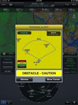
Garmin Pilot v5.1 features the ability to overlay terrain and obstacles simultaneously on the moving map page. Adding to its feature-rich capabilities, pilots have the ability to view the moving map page in a track-up format, ensuring flight plan information is upright and easy to read. Garmin Pilot's dedicated terrain page displays terrain and obstacles in either an arc or 360-degree view, further enhancing situational awareness.
Garmin Pilot uses intuitive colors to help the pilot discern, at a glance, their proximity to terrain. In addition, it provides a visual Caution or Warning alert for potential conflicting terrain and obstacles given the aircraft’s projected flight path. Terrain data leverages highly detailed data found in Garmin avionics and portables and comes in various resolutions to provide pilots the flexibility to select the level of detail they prefer for their device.
A new time-saving feature of Garmin Pilot is ATC Preferred Routing, which displays historical routes that have been cleared by the FAA to other aircraft flying the same departure/destination pair. Pilots can easily filter between the most popular, most recent, types of aircraft and altitudes used to fly the route. By doing so, pilots can evaluate routes that have the best chances of being accepted – thus helping reduce pilot workload before take-off or while en route. Additionally, Garmin Pilot now includes the ability to select a runway while loading Standard Terminal Arrival Routes (STARs) and Standard Instrument Departure Procedures (SIDs) into the flight plan.
Garmin continues to enhance our application for Android equipped pilots, with Garmin Pilot v2.6 which includes multi-layer map support, allowing pilots to select multiple overlays like radar and lightning to display on the map simultaneously. ATC Preferred Routing, described above, is also available in the Android update. Terrain and obstacle features are not yet available for Android devices.
The latest version of Garmin Pilot is available immediately in the U.S. as a free update for existing iOS Garmin Pilot subscribers. For new customers, it is available in the Apple App Store as a free trial for the first 30 days. After that, pilots can subscribe to Garmin Pilot with graphical obstacles and terrain topography starting at $24.99 for three months or $74.99 annually. Pilots can optionally upgrade to the VFR Premium which includes Geo-referenced SafeTaxi diagrams along with terrain alerts for $49.99 annually. The optional IFR Premium, which adds terrain alerts, geo-referenced FliteCharts and SafeTaxi diagrams, is an additional $74.99 annually.
(Image provided by Garmin)
 ANN's Daily Aero-Term (04.25.24): Airport Rotating Beacon

