Aero-Tips!
A good pilot is always learning -- how many times have you heard
this old standard throughout your flying career? There is no truer
statement in all of flying (well, with the possible exception of
"there are no old, bold pilots.")

Aero-News has called upon the expertise of Thomas P. Turner,
master CFI and all-around-good-guy, to bring our readers -- and us
-- daily tips to improve our skills as aviators. Some of them, you
may have heard before... but for each of us, there will also be
something we might never have considered before, or something that
didn't "stick" the way it should have the first time we memorized
it for the practical test.
Look for our daily Aero-Tips segments, coming each day to you
through the Aero-News Network.
Aero-Tips 08.13.06
We hear about them a lot out here in Kansas... but for many "bow
echo" is a new term. Here's why you need to know the
implications of this phenomenon.
A bow echo is a radar return shaped like an archery bow. It is a
visual representation of an extreme gust of wind, usually the
outflow from a severe thunderstorm. Bow echos often result from a
line of convective cells associated with damaging straight-line
winds and small tornadoes. Bow echoes include an intense inflow of
wind at the core of the bow, with book-end or line-end vortices
behind the ends of the bow.
Bow echoes have been observed with scales between 20 and 200
kilometers, with lifetimes from three and six hours. At early
stages in their evolution, both cyclonic and anticyclonic book-end
vortices tend to be of similar strength, but later in the
evolution, the northern cyclonic vortex often dominates, giving the
convective system a comma-shaped appearance.
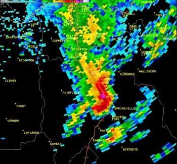
Salt Lake scenario
A bow echo event in and near Salt Lake City, Utah on August 1,
2006, was so intense that the National Weather Service (NWS) has
posted a web page specifically describing the
scenario and its aftermath. Two bow echoes impacted the Wasatch
Front. Both bow echoes produced damaging straight-line winds near
the apex of the bow segment, characteristic of this type of severe
thunderstorm. Peak wind gusts were measured at 92 mph at the Provo
Airport and estimated between 60 and 70 mph in East Millcreek of
Salt Lake County. Rainfall was very intense with these
thunderstorms as many areas in the southern Wasatch Front observed
one half to one inch in less than 30 minutes. Hail stones as large
as ¾ of an inch in diameter were observed with the
thunderstorms in Provo. Preliminary damage estimates in Utah County
were around $13 million.
The NWS site even has a recorded radar loop of the
Salt Lake event. Yellow boxes in the loop are Severe Thunderstorm
Warnings issued by the National Weather Service.
Why it's important for pilots
Hail accumulated on the Provo Airport runways and was still
present in piles during the evening hours. There was also
considerable damage to small airplanes which were toppled over by
the wind, and to buildings which had roofs and siding partially or
totally torn away at the Provo Airport.
Aero-tip of the day: See a bow echo on radar?
Avoid the extreme turbulence, and expect its effects to last long
after the storm passes. You may have to divert elsewhere even after
the skies clear. If you see a bow echo while your plane is on the
ground, get it inside if possible... and hope the hangar holds
together.
 ANN's Daily Aero-Linx (05.02.24)

