New TIAGA Software Will Help Pilots Make Better Decisions When Internet Is Not Available
NASA has formally delivered to Alaskan officials a new technology that could help pilots flying over the vast wilderness expanses of the northern-most state. The technology is designed to help pilots make better flight decisions, especially when disconnected from the Internet, telephone, flight services and other data sources normally used by pilots.
S. Peter Worden, director of NASA's Ames Research Center in Moffett Field, California, and Thomas Edwards, Director of Aeronautics at Ames, met with Alaskan officials Monday to deliver the software innovation known as the Traffic and Atmospheric Information for General Aviation (TAIGA). This aviation technology, a collection of algorithms, concepts and data, is the result of a joint effort between Ames and the State of Alaska.
Over the vast expanses of Alaska, with its mountainous terrain and extreme weather events, pilots often are disconnected from vital navigation aids and communication. Taking on these factors, NASA developed a satellite-based communication method through which regional data is sent only to that specific region. The customized data sets can be downloaded quickly and plugged into a mobile application.
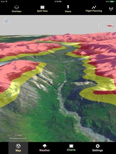
NASA has developed only a conceptual version of the mobile software application, which includes full 3-D terrain visualization. The algorithms, concepts and data are available as an open-source project for further development by industry and the aviation community into an end-user system. The 3-D terrain visualization software will be made available separately.
"We are excited to lend a helping hand to general aviation pilots in Alaska," said Worden. "With the TAIGA app, Alaska pilots will be able to remain independent, but with a dose of safety when needed."
In a recent test at Ames, data from a satellite-based messaging system was successfully received on the satellite receiver and viewed on the concept version of the mobile app while in flight. Since sending data via satellite can be expensive, NASA also developed a method for tightly bundling the data to be transmitted, thereby decreasing the cost of satellite data transmission using this technology.
"Each data broadcast will go only to the areas that are appropriate for those data," said Joseph Rios, TAIGA engineer at Ames. "Once a pilot receives a data broadcast, it will be available for viewing on their iPad."
The next step in development of the TAIGA concept will be for engineers with the State of Alaska to take the NASA concept and develop it to an app that meets the specific needs of Alaskan pilots. Ames will continue to investigate new functionalities, and Alaskan officials hope to distribute a production prototype app to general aviation pilots for testing early next year.
Ames is a leader is developing decision support tools that help air traffic managers maintain and enhance the safety and efficiency of the National Airspace System (NAS). NASA's Next Generation Air Transportation System (NextGen) is a comprehensive transformation of the NAS, which includes all components, such as airspace, facilities, equipment, services, workforce and procedures that enable the nation's air transportation system.
Part of the NextGen effort, TAIGA specifically focuses on increasing safety for pilots in Alaska. The technology is the product of a Space Act Agreement between Ames and the State of Alaska to collaborate on space exploration, advanced aviation, scientific research, and science, technology, engineering and mathematics education initiatives.
(Image provided by NASA. TAIGA is capable of showing pilots the altitude of nearby terrain via color. Yellow identifies terrain that is near the aircraft’s altitude and red shows the terrain that is higher than the plane’s altitude)
 ANN's Daily Aero-Term (04.25.24): Airport Rotating Beacon

