Four People, Including A Patient, Were Fatally Injured
The NTSB has released its probable cause report from an accident involving a Eurocopter AS350 B2 helicopter registered to Haynes Life Flight LLC and operated by Metro Aviation which fatally injured four people on board the aircraft, including a patient being transported to a hospital.
According to the report, after picking up a patient at a motor vehicle accident (MVA) site near Enterprise, AL, the airline transport pilot of the helicopter air ambulance flight, which was operating under visual flight rules (VFR), departed in dark night instrument meteorological conditions (IMC) to transport the patient to a hospital; a flight nurse and paramedic were also on board. Witness statements, video, and photographs indicated that reduced visibility in fog and mist as well as very-light-to-light precipitation existed at the MVA site, and the nearest weather station, 4 miles away, was reporting a 300-ft ceiling and 3 miles visibility. Radar data indicated that, after takeoff, the helicopter entered a left turn and climbed to 1,000 ft above mean sea level (msl). The rate of turn then began to increase, and, after reaching a peak altitude of 1,100 ft msl, the helicopter began a rapid descent that continued to ground impact. According to the radar data, the flight lasted about 1 minute. A
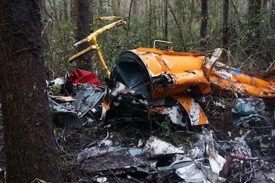
search was initiated when the pilot did not check in with the communications center as required, and the wreckage was located the next morning about 1/2 mile from the departure location. Examination of the accident site and wreckage revealed that the helicopter struck trees and terrain and was highly fragmented. Examination of the wreckage did not reveal evidence of any preimpact malfunctions or failures that would have precluded normal operation of the helicopter.
Although the helicopter was not certificated for flight in IMC, it had sufficient instrumentation to operate in the event of an inadvertent encounter with IMC and was equipped with a helicopter terrain avoidance warning system, a night vision imaging system which included night vision goggles (NVGs), and an autopilot. The pilot had about 265 hours experience operating in IMC and had been trained in inadvertent IMC loss of control recovery, but he was not instrument current. Further, he had not been trained or qualified by the operator to fly in IMC. He was likely using NVGs during the flight as one of the first responders who helped load the patient into the helicopter saw the pilot wearing them. Based on the weather conditions, the flight path of the helicopter, and the lack of preimpact failures or anomalies, it is likely that the pilot experienced spatial disorientation after entering IMC and subsequently lost control of the helicopter.
To accomplish operational control of its flights, the operator used an operational control center (OCC) that was staffed 24 hours a day by operational control coordinators. According to the operator, the pilot had the final authority and responsibility for decisions relating to safety of flight, and the operational control coordinators were responsible for confirming whether a flight or series of flights could be initiated, conducted, or terminated safely, in accordance with the authorizations, limitations, and procedures in their operations manual, and the applicable regulations. In the case of the accident flight, the operator's required VFR weather minimums were a 1,000-ft ceiling with a flight visibility of 3 miles.
The operational control coordinators' role was accomplished by inputting flight data into software programs that would perform automated database queries for pilot currency and aircraft maintenance information and would provide weather information based upon route of flight. Both OCC personnel and pilots had the authority to terminate a flight at any time if required conditions were not met. There were two personnel on duty before and during the time of the accident at the operator's OCC, a trainee operational control coordinator and a senior operational control coordinator. About 1 hour before the helicopter accident, the OCC received notification of the request for the helicopter to respond to the MVA, and the coordinators used a software program called "OCC Helper" to query weather information. Although the coordinates for the location of the MVA provided to the OCC were correct, the format of the coordinates was not the correct format for OCC Helper. Therefore, the OCC Helper software only
recognized the MVA site as being near the helicopter's base, which was reporting visual meteorological conditions, and did not show the IMC being reported at weather stations closer to the MVA site. The trainee reported that latitude and longitude format was a common problem with OCC Helper and, at times, required OCC personnel to reformat the latitude and longitude coordinates to get the coordinates to work in OCC Helper. On the night of the accident, the incorrectly formatted latitude and longitude for the MVA site were not corrected in OCC Helper until after the helicopter had departed its base en route to the MVA site. Given the IMC weather conditions being reported, which were below the required VFR weather minimums for the flight, the OCC coordinators should have provided the pilot with additional weather information after they had correctly input the coordinates of the MVA site into the OCC Helper software; however, they did not do so. The lack of monitoring of the flight by the OCC through direct
human interaction due to overreliance on mission support software and other automated aids, and the incorrectly interpreted latitude and longitude information by both the software and the operational control coordinators resulted in a loss of operational control. Although the software formatting issues were known, there was no standard operating procedure to mitigate the problem.
The pilot had access to internet-based weather information at the helicopter's base, but it is unknown what weather information the pilot reviewed before beginning the flight to the MVA. However, text messages between the pilot and a friend and between the flight nurse on the accident flight and the same friend indicated that the pilot was aware of the possibility of encountering IMC before he departed the base for the MVA site. Further, after landing at the MVA, the pilot would have been aware that the weather conditions at the site were below the company's VFR weather minimums. Given the weather conditions at the MVA site, the pilot should have canceled the flight or, at a minimum, contacted the OCC to obtain updated weather information and guidance. However, the pilot's fixation on completing the mission probably motivated him to depart on the accident flight in IMC, even though significantly less risky alternatives existed, such as canceling the flight and transporting the patient by ground
ambulance.
The NTSB determined the probable cause(s) of this accident to be the pilot's decision to perform visual flight rules flight into night instrument meteorological conditions, which resulted in loss of control due to spatial disorientation. Contributing to the accident was the pilot's self-induced pressure to complete the mission despite the weather conditions and the operator's inadequate oversight of the flight by its operational control center.
(Image from NTSB accident docket)
 Unfortunate... ANN/SportPlane Resource Guide Adds To Cautionary Advisories

