NASA Mars Orbiter Views Rover Crossing Into New Zone | Aero-News Network
Aero-News Network
RSS icon RSS feed
podcast icon MP3 podcast
Subscribe Aero-News e-mail Newsletter Subscribe

Airborne Unlimited -- Most Recent Daily Episodes

Episode Date

Airborne-Monday

Airborne-Tuesday

Airborne-Wednesday Airborne-Thursday

Airborne-Friday

Airborne On YouTube

Airborne-Unlimited-04.29.24

Airborne-Unlimited-04.23.24

Airborne-Unlimited-04.24.24 Airborne-FltTraining-04.25.24

Airborne-Unlimited-04.26.24

Fri, Jul 11, 2014

NASA Mars Orbiter Views Rover Crossing Into New Zone

Now Out Of The Area Mapped Out For Its 2012 Landing

NASA Mars rover Curiosity has driven out of the ellipse, approximately 4 miles wide and 12 miles long, that was mapped as safe terrain for its 2012 landing inside Gale Crater.

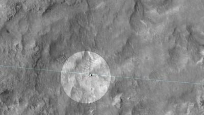
The High Resolution Imaging Science Experiment (HiRISE) camera on NASA's Mars Reconnaissance Orbiter photographed the rover on June 27 at the end of a drive that put Curiosity right on the ellipse boundary.

The landing ellipse is the area within which the rover had a very high probability of touching down when it arrived at Mars on Aug. 5, 2012, PDT (Aug. 6, UTC). The area needed to meet requirements for providing access to scientifically interesting sites while presenting few landing hazards, such as steep slopes or large boulders. Many areas of scientific interest have slopes ineligible for landing safety, and Curiosity was designed to have the capability of driving far enough to get to slopes outside of the landing ellipse. Since landing, Curiosity has driven slightly more than 5 miles.

NASA's Mars Science Laboratory Project is using Curiosity to assess ancient habitable environments and major changes in Martian environmental conditions.

(Image provided by NASA. This June 27, 2014, image from the HiRISE camera on NASA's Mars Reconnaissance Orbiter shows NASA's Curiosity Mars rover on the rover's landing-ellipse boundary, which is superimposed on the image. The 12-mile-wide ellipse was mapped as safe terrain for its 2012 landing inside Gale Crater)

FMI: www.nasa.gov

Advertisement

More News

Unfortunate... ANN/SportPlane Resource Guide Adds To Cautionary Advisories

The Industry Continues to be Rocked By Some Questionable Operations Recent investigations and a great deal of data has resulted in ANN’s SportPlane Resource Guide’s rep>[...]

ANN FAQ: Turn On Post Notifications

Make Sure You NEVER Miss A New Story From Aero-News Network Do you ever feel like you never see posts from a certain person or page on Facebook or Instagram? Here’s how you c>[...]

ANN's Daily Aero-Term (04.29.24): Visual Approach Slope Indicator (VASI)

Visual Approach Slope Indicator (VASI) An airport lighting facility providing vertical visual approach slope guidance to aircraft during approach to landing by radiating a directio>[...]

ANN's Daily Aero-Term (04.28.24): Airport Marking Aids

Airport Marking Aids Markings used on runway and taxiway surfaces to identify a specific runway, a runway threshold, a centerline, a hold line, etc. A runway should be marked in ac>[...]

ANN's Daily Aero-Linx (04.28.24)

Aero Linx: The Skyhawk Association The Skyhawk Association is a non-profit organization founded by former Skyhawk Pilots which is open to anyone with an affinity for the A-4 Skyhaw>[...]

blog comments powered by Disqus


Advertisement

Advertisement

Podcasts

Advertisement

© 2007 - 2024 Web Development & Design by Pauli Systems, LC