Hurricane Michael: FAA Information For Drone Operators | Aero-News Network
Aero-News Network
RSS icon RSS feed
podcast icon MP3 podcast
Subscribe Aero-News e-mail Newsletter Subscribe

Airborne Unlimited -- Most Recent Daily Episodes

Episode Date

Airborne-Monday

Airborne-Tuesday

Airborne-Wednesday Airborne-Thursday

Airborne-Friday

Airborne On YouTube

Airborne-Unlimited-04.29.24

Airborne-Unlimited-04.23.24

Airborne-Unlimited-04.24.24 Airborne-FltTraining-04.25.24

Airborne-Unlimited-04.26.24

Thu, Oct 11, 2018

Hurricane Michael: FAA Information For Drone Operators

Fines For Flying In Restricted Areas May Exceed $20,000

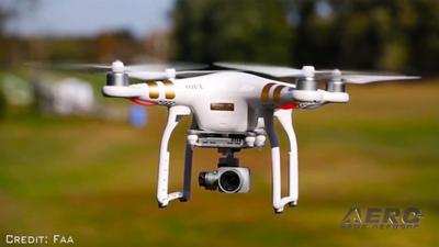
The FAA is warning drone owners and operators that they will be subject to significant fines that may exceed $20,000 if they interfere with emergency response operations in the areas affected by Hurricane Michael.

Many aircraft that are conducting life-saving missions and other critical response and recovery efforts are likely to be flying at low altitudes over areas affected by the storm. Flying a drone without authorization in or near the disaster area may unintentionally disrupt rescue operations and violate federal, state, or local laws and ordinances, even if a Temporary Flight Restriction (TFR) is not in place. Allow first responders to save lives and property without interference.

Government agencies with an FAA Certificate of Authorization (COA) or flying under Part 107, as well as private sector Part 107 drone operators who want to support response and recovery operations, are strongly encouraged to coordinate their activities with the local incident commander responsible for the area in which they want to operate.

If drone operators need to fly in controlled airspace or a disaster TFR to support the response and recovery, operators must contact the FAA’s System Operations Support Center (SOSC) by emailing 9-ATOR-HQ-SOSC@faa.gov the information they need to authorize access to the airspace. Coordination with the SOSC may also include a requirement that a drone operator obtain support from the appropriate incident commander.

Here’s the information the FAA may require:

  • the unmanned aircraft type
  • a PDF copy of a current FAA COA
  • the pilot’s Part 107 certificate number
  • details about the proposed flight (date, time, location, altitude, direction and distance to the nearest airport, and latitude/longitude)
  • nature of the event (fire, law enforcement, local/national disaster, missing person) and the pilot’s qualification information.

(Source: FAA news release. Image from file)

FMI: www.faa.gov

Advertisement

More News

ANN's Daily Aero-Term (04.26.24): DETRESFA (Distress Phrase)

DETRESFA (Distress Phrase) The code word used to designate an emergency phase wherein there is reasonable certainty that an aircraft and its occupants are threatened by grave and i>[...]

Aero-News: Quote of the Day (04.26.24)

"General aviation is at the forefront of developing and introducing innovative technologies that will transform the entire aviation industry..." Source: Kyle Martin, Vice President>[...]

ANN's Daily Aero-Term (04.27.24): Direct

Direct Straight line flight between two navigational aids, fixes, points, or any combination thereof. When used by pilots in describing off-airway routes, points defining direct ro>[...]

ANN's Daily Aero-Linx (04.27.24)

Aero Linx: Women in Corporate Aviation Women in Corporate Aviation support individuals seeking career advancement and professional development in the business aviation industry. Me>[...]

Aero-News: Quote of the Day (04.27.24)

“We would like to thank the many volunteers that help throughout the year to pull off the event, as well as the several reviewers, judges, and SURVICE staff that provide team>[...]

blog comments powered by Disqus


Advertisement

Advertisement

Podcasts

Advertisement

© 2007 - 2024 Web Development & Design by Pauli Systems, LC