Thu, Dec 06, 2018
Fire Charred 88% Of National Park Service Land Within The Santa Monica Mountains National Recreation Area
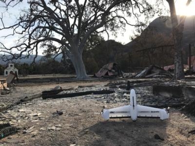
The National Park Service Inventory and Monitoring Program used AeroVironment’s Quantix hybrid drone and Decision Support System (AV DSS) advanced data analytics platform to assess the environmental impact of the Woolsey wildfire in the Santa Monica Mountains National Recreation Area of Southern California. Burning over 96,949 acres, the devastating Woolsey wildfire destroyed more than 616 park structures and consumed approximately 88% of National Park Service land within the recreation area. The Santa Monica Mountains National Recreation Area is also home to a wide variety of indigenous plants and animals, including multiple protected and endangered species.
Working in close collaboration with National Park Service park rangers and scientists, AeroVironment Commercial Information Solutions Unmanned Aircraft Systems flight operations and Geographic Information Science teams have initiated a comprehensive drone-based aerial imaging and environmental impact study to assess fire damage in key areas of the park. Aerial imagery data collected will be used to quantify oak tree mortality and vegetation stress, in addition to documenting the dramatic changes in park visitor experience.
The drone was used to capture high-resolution aerial imagery and quickly map the affected burn area, leading to actionable insights into the scope and scale of the damage. In addition to immediate disaster response and damage assessment, data collected will facilitate the development of a long-term environmental recovery and park rebuilding strategy.
Purpose built for commercial applications including precision agriculture, infrastructure and mining operations, the Quantix hybrid drone innovative VTOL technology allows it to operate effectively in a variety of conditions, and can survey up to 400 acres in just 45 minutes. During flight, Quantix integrated sensors capture high-resolution RGB color and multispectral imagery via dual 18MP cameras. On-board processing delivers true color and normalized difference vegetation index (NDVI) maps on the Quantix control tablet as soon as the drone lands, allowing teams to ground-truth potential issues immediately. For more detailed analysis, the AeroVironment Decision Support System (AV DSS) performs advanced image processing and data analytics including True Color, NDVI, GNDVI, and anomaly detection to gain deeper insights into environmental damage and vegetation health.
(Image provided with AeroVironment news release)
More News
Airport Marking Aids Markings used on runway and taxiway surfaces to identify a specific runway, a runway threshold, a centerline, a hold line, etc. A runway should be marked in ac>[...]
"It is extremely difficult, if not impossible, for manned aircraft to see a drone while conducting crop-enhancing and other aerial applications at low altitudes and high speeds. We>[...]
Aero Linx: The Skyhawk Association The Skyhawk Association is a non-profit organization founded by former Skyhawk Pilots which is open to anyone with an affinity for the A-4 Skyhaw>[...]
“The T-54A benefits from an active Beechcraft King Air assembly line in Wichita, Kansas, where all required METS avionics and interior modifications are installed on the line>[...]
Aero Linx: Aerostar Owners Association The Association offers the Aerostar Owner a unique opportunity to tap an invaluable source of information concerning the care and feeding of >[...]
 ANN's Daily Aero-Term (04.28.24): Airport Marking Aids

