Fri, Mar 06, 2020
Lufthansa Systems, Intermap Technologies Obtain First EASA Certification For Global Terrain Data
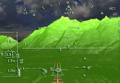
Lufthansa Systems and Intermap Technologies announced that Lido Surface Data NEXTView has received the Service Provider Type 1 Certificate from EASA. Lido Surface Data NEXTView is the world’s first high-resolution, global terrain dataset specifically designed for the aviation industry. It provides the highest quality of data with continual updates and incorporates Lido’s aerodrome database, significantly increasing the accuracy around aerodromes. The solution is currently the only certified digital surface model on the market that fulfills all relevant industry standards.
Lido Surface Data NEXTView was developed in collaboration with Intermap Technologies, an industry leader in geospatial intelligence solutions with long-standing expertise in the field of digital elevation models. “We are extremely proud to be the first to receive an EASA certificate for our newly developed terrain product,” said Michael Sauter, Senior Product Owner for Aeronautical Data at Lufthansa Systems. “Lido Surface Data NEXTView is further enriching our aeronautical data portfolio and provides a fundamental database for the increasingly digitally driven future of mobility.”
With the newly certified terrain product, Lufthansa Systems is enabling the aviation industry to further enhance solutions such as:
- synthetic vision systems (SVS) as well as enhanced and combined vision systems (EVS, CVS), which provide pilots with greater situational awareness; and
- terrain awareness and ground proximity warning systems (TAWS, EGPWS), which allow aircraft and helicopters to maintain a safe distance from the ground.
Furthermore, the solution serves the wider aviation market by enabling the development of innovative applications for:
- flight planning, procedure design and performance calculations; and
- drone operations and drone planning, increasing the efficiency of flight operations.
“This announcement is a milestone for Intermap Technologies’ data business,” said Patrick Blott, Chairman and CEO of Intermap Technologies. “With the certification of Lido Surface Data NEXTView, we are now able to work with our partners at Lufthansa Systems to consistently and globally deliver high-resolution information that aviators and airlines need to improve the customer experience, navigation and safety. Commercial airlines, UAV companies and governments all over the world can rely on their subscriptions to the Lido Surface Data NEXTView data to power critical automated systems and make flying even safer and more efficient.”
(Image provided with Lufthansa Systems news release)
More News
The Industry Continues to be Rocked By Some Questionable Operations Recent investigations and a great deal of data has resulted in ANN’s SportPlane Resource Guide’s rep>[...]
Make Sure You NEVER Miss A New Story From Aero-News Network Do you ever feel like you never see posts from a certain person or page on Facebook or Instagram? Here’s how you c>[...]
Visual Approach Slope Indicator (VASI) An airport lighting facility providing vertical visual approach slope guidance to aircraft during approach to landing by radiating a directio>[...]
Airport Marking Aids Markings used on runway and taxiway surfaces to identify a specific runway, a runway threshold, a centerline, a hold line, etc. A runway should be marked in ac>[...]
Aero Linx: The Skyhawk Association The Skyhawk Association is a non-profit organization founded by former Skyhawk Pilots which is open to anyone with an affinity for the A-4 Skyhaw>[...]
 Unfortunate... ANN/SportPlane Resource Guide Adds To Cautionary Advisories

