ANN's Daily Aero-Tips (08.17.06): Hazardous Area Reporting Service | Aero-News Network
Aero-News Network
RSS icon RSS feed
podcast icon MP3 podcast
Subscribe Aero-News e-mail Newsletter Subscribe

Airborne Unlimited -- Most Recent Daily Episodes

Episode Date

Airborne-Monday

Airborne-Tuesday

Airborne-Wednesday Airborne-Thursday

Airborne-Friday

Airborne On YouTube

Airborne-Unlimited-04.29.24

Airborne-Unlimited-04.23.24

Airborne-Unlimited-04.24.24 Airborne-FltTraining-04.25.24

Airborne-Unlimited-04.26.24

Thu, Aug 17, 2006

ANN's Daily Aero-Tips (08.17.06): Hazardous Area Reporting Service

Aero-Tips!

A good pilot is always learning -- how many times have you heard this old standard throughout your flying career? There is no truer statement in all of flying (well, with the possible exception of "there are no old, bold pilots.")

Aero-News has called upon the expertise of Thomas P. Turner, master CFI and all-around-good-guy, to bring our readers -- and us -- daily tips to improve our skills as aviators. Some of them, you may have heard before... but for each of us, there will also be something we might never have considered before, or something that didn't "stick" the way it should have the first time we memorized it for the practical test.

Look for our daily Aero-Tips segments, coming each day to you through the Aero-News Network.

Aero-Tips 08.17.06

Generally it's ill-advised to overfly extensive areas of hazardous terrain or water, especially in single-engine airplanes (no, the airplane doesn't know you're over water, but if the engine happens to quit you'll soon become aware of the consequences).

If your decision-making permits you to take the risk, yet you do not need or want to file IFR or participate in Flight Following, you have another option to expedite search and rescue. It's called the Hazardous Area Reporting Service (HARS).

Note: When making this decision, think about why the Feds are compelled to go to all this trouble and created special search-and-rescue procedures for overflying these hazards.

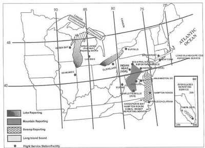
HARS provides Flight Service Station (FSS) monitoring where visual flight rules (VFR) routes cross large bodies of water or swamps. To participate, call a FSS and:

  • Give type of aircraft, altitude, indicated airspeed, present position, route of flight, and heading information.
  • Make radio contact at least every 10 minutes.

This means flying high to assure radio coverage throughout the flight... and to give you range to glide away from the hazard if an engine quits. 

If contact is lost for more than 15 minutes, Search and Rescue will be alerted. Pilots are responsible for canceling service once outside the service area boundary. Pilots experiencing two-way radio failure are expected to land as soon as practicable and cancel the request for the service.

HARS is available for:

  • Long Island Sound
  • Block Island (New York)
  • Cape Cod and islands
  • Appalachian Mountains
  • Chesapeake Bay/Hampton Roads/Great Dismal Swamp
  • Lake Erie; Lake Michigan and Green Bay
  • Everglades

Specific procedures and frequencies for each HARS area are contained in the Aeronautical Information Manual (AIM).

Aero-tip of the day: Avoid flying over hazardous areas. If you can't, fly high and file IFR or participate in Flight Following to trigger a fast rescue response if needed. If you can't or won't, fly high and use the Hazardous Area Reporting Service.

FMI: Aero-Tips

Advertisement

More News

Unfortunate... ANN/SportPlane Resource Guide Adds To Cautionary Advisories

The Industry Continues to be Rocked By Some Questionable Operations Recent investigations and a great deal of data has resulted in ANN’s SportPlane Resource Guide’s rep>[...]

ANN FAQ: Turn On Post Notifications

Make Sure You NEVER Miss A New Story From Aero-News Network Do you ever feel like you never see posts from a certain person or page on Facebook or Instagram? Here’s how you c>[...]

ANN's Daily Aero-Term (04.29.24): Visual Approach Slope Indicator (VASI)

Visual Approach Slope Indicator (VASI) An airport lighting facility providing vertical visual approach slope guidance to aircraft during approach to landing by radiating a directio>[...]

ANN's Daily Aero-Term (04.28.24): Airport Marking Aids

Airport Marking Aids Markings used on runway and taxiway surfaces to identify a specific runway, a runway threshold, a centerline, a hold line, etc. A runway should be marked in ac>[...]

ANN's Daily Aero-Linx (04.28.24)

Aero Linx: The Skyhawk Association The Skyhawk Association is a non-profit organization founded by former Skyhawk Pilots which is open to anyone with an affinity for the A-4 Skyhaw>[...]

blog comments powered by Disqus


Advertisement

Advertisement

Podcasts

Advertisement

© 2007 - 2024 Web Development & Design by Pauli Systems, LC