Thu, Feb 18, 2010
Compatible With The GNS 430W/530W Family
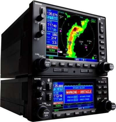
 Garmin
International has unveiled a new Helicopter Terrain Awareness and
Warning System (HTAWS) for the GNS 430W/530W series navigators.
HTAWS is available as an option on newly purchased systems or as a
field upgrade for current owners. When added to the GNS 430W/530W
navigators, operators will receive graphical and audible alerts of
potential terrain and obstacle conflicts along the flight path. The
announcement was made Thursday afternoon.
Garmin
International has unveiled a new Helicopter Terrain Awareness and
Warning System (HTAWS) for the GNS 430W/530W series navigators.
HTAWS is available as an option on newly purchased systems or as a
field upgrade for current owners. When added to the GNS 430W/530W
navigators, operators will receive graphical and audible alerts of
potential terrain and obstacle conflicts along the flight path. The
announcement was made Thursday afternoon.
"Garmin is serious about safety, and HTAWS is life saving
technology that will increase safety of flight," said Gary Kelley,
Garmin's vice president of marketing.
Garmin's HTAWS has forward looking terrain avoidance (FLTA)
capability with visual and aural advisories to keep pilots advised
of hazardous terrain. It incorporates a new five color terrain
scale (red, orange, yellow, green and black), and also gives
terrain voice alerts when descending below 500 feet. Voice callouts
operate in all HTAWS modes, and Garmin's technology allows the
pilot to select multiple callouts, in one hundred foot intervals,
descending from 500 to 100 feet above ground level (AGL). In
addition, Garmin's HTAWS offers a reduced protection (RP) mode that
allows low-level operations with minimal alerting while continuing
to provide terrain and obstacle protection.
Garmin has incorporated three new helicopter specific databases
for HTAWS. The obstacle database adds nearly 30,000 additional
low-altitude obstacles. The new terrain database has been enhanced
to show higher resolution. The navigation database lets operators
navigate to over 7,000 heliports without having to create user
waypoints at those locations.
In addition to viewing HTAWS information on the GNS 430W/530W
series, rotorcraft operators who have also installed the new G500H
can display all HTAWS annunciations on the G500H's large PFD and
MFD.
Garmin's HTAWS is expected to be certified and available in the
second quarter of 2010 for $9,995 as a field-upgrade or as an
option on new GNS 430W/530W series products.
More News
Aero Linx: JAARS Nearly 1.5 billion people, using more than 5,500 languages, do not have a full Bible in their first language. Many of these people live in the most remote parts of>[...]
'Airplane Bounced Twice On The Grass Runway, Resulting In The Nose Wheel Separating From The Airplane...' Analysis: The pilot reported, “upon touchdown, the plane jumped back>[...]
"Burt is best known to the public for his historic designs of SpaceShipOne, Voyager, and GlobalFlyer, but for EAA members and aviation aficionados, his unique concepts began more t>[...]
"Polaris Dawn, the first of the program’s three human spaceflight missions, is targeted to launch to orbit no earlier than summer 2024. During the five-day mission, the crew >[...]
There Are SO Many Ways To Get YOUR Aero-News! It’s been a while since we have reminded everyone about all the ways we offer your daily dose of aviation news on-the-go...so he>[...]
 ANN's Daily Aero-Linx (05.04.24)

