NASA Mars Orbiter Spies Rover Near Martian Butte | Aero-News Network
Aero-News Network
RSS icon RSS feed
podcast icon MP3 podcast
Subscribe Aero-News e-mail Newsletter Subscribe

Airborne Unlimited -- Most Recent Daily Episodes

Episode Date

Airborne-Monday

Airborne-Tuesday

Airborne-Wednesday Airborne-Thursday

Airborne-Friday

Airborne On YouTube

Airborne-Unlimited-04.29.24

Airborne-Unlimited-04.23.24

Airborne-Unlimited-04.24.24 Airborne-FltTraining-04.25.24

Airborne-Unlimited-04.26.24

Mon, Apr 21, 2014

NASA Mars Orbiter Spies Rover Near Martian Butte

Curiosity Spotted At Work Near 'Mount Remarkable'

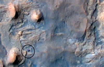
Scientists using NASA's Curiosity Mars rover are eyeing a rock layer surrounding the base of a small butte, called "Mount Remarkable," as a target for investigating with tools on the rover's robotic arm. And this image of the rover at work was captured April 11 by the High Resolution Imaging Science Experiment (HiRISE) camera on NASA's Mars Reconnaissance Orbiter.

The butte stands about 16 feet high. Curiosity's science team refers to the rock layer surrounding the base of Mount Remarkable as the "middle unit" because its location is intermediate between rocks that form buttes in the area and lower-lying rocks that show a pattern of striations.

Depending on what the mission scientists learn from a close-up look at the rock and identification of chemical elements in it, a site on this middle unit may become the third rock that Curiosity samples with its drill. The rover carries laboratory instruments to analyze rock powder collected by the drill. The mission's first two drilled samples, in an area called Yellowknife Bay near Curiosity's landing site, yielded evidence last year for an ancient lakebed environment with available energy and ingredients favorable for microbial life.

The rover's current location, where multiple types of rocks are exposed close together, is called "the Kimberley." Here and, later, at outcrops on the slope of Mount Sharp inside Gale Crater, researchers plan to use Curiosity's science instruments to learn more about habitable past conditions and environmental changes.

(Image provided by NASA)

FMI: www.nasa.gov/msl

Advertisement

More News

Unfortunate... ANN/SportPlane Resource Guide Adds To Cautionary Advisories

The Industry Continues to be Rocked By Some Questionable Operations Recent investigations and a great deal of data has resulted in ANN’s SportPlane Resource Guide’s rep>[...]

ANN FAQ: Turn On Post Notifications

Make Sure You NEVER Miss A New Story From Aero-News Network Do you ever feel like you never see posts from a certain person or page on Facebook or Instagram? Here’s how you c>[...]

ANN's Daily Aero-Term (04.29.24): Visual Approach Slope Indicator (VASI)

Visual Approach Slope Indicator (VASI) An airport lighting facility providing vertical visual approach slope guidance to aircraft during approach to landing by radiating a directio>[...]

ANN's Daily Aero-Term (04.28.24): Airport Marking Aids

Airport Marking Aids Markings used on runway and taxiway surfaces to identify a specific runway, a runway threshold, a centerline, a hold line, etc. A runway should be marked in ac>[...]

ANN's Daily Aero-Linx (04.28.24)

Aero Linx: The Skyhawk Association The Skyhawk Association is a non-profit organization founded by former Skyhawk Pilots which is open to anyone with an affinity for the A-4 Skyhaw>[...]

blog comments powered by Disqus


Advertisement

Advertisement

Podcasts

Advertisement

© 2007 - 2024 Web Development & Design by Pauli Systems, LC