Mon, Feb 15, 2010
Aircraft Enhances Capabilities In Mountainous Terrain
Late last month, EADS Defence & Security delivered 35
specially modified new unmanned air vehicle (UAV) DRAC systems to
the French Army to enhance its capabilities in mountainous terrain,
the company said Thursday. This delivery took place at the end of a
series of ground-based and in-flight verification operations
launched in November 2009 and carried out together with the French
defence procurement agency DGA (Direction Generale de l'Armement).
The new batch follows a first batch of 25 DRAC systems delivered to
the Ministry of Defence in July 2008.
The systems delivered this year will contribute to the safety of
French troops deployed in very hostile theaters of operation and
will improve the efficiency of their missions.
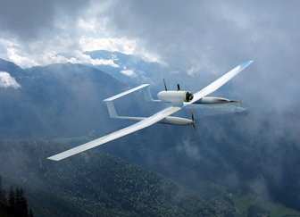
As far as its design is concerned, the DRAC system combines
highly advanced technology with flexibility in its implementation
and use, providing the forces with enhanced military capabilities
in its function as a short-range, cost-efficient drone adapted to
the requirements of modern armies.
DRAC is based on the TRACKER system developed by EADS in
collaboration with the French SME SurveyCopter in compliance with
extremely strict specifications laid down by the French customer.
SurveyCopter is supplying the aerial vehicle and the daytime and
night-time cameras. EADS, as prime contractor, is integrating the
system with a special ground station and a secure, high-speed,
digital datalink with an automatic tracking function, which gives
the system a genuine long-range capability even in severe weather
conditions. DRAC's high level of security will make it eligible for
type certification as of this year.
The DRAC system is very practically packaged in two separate
rucksacks so that missions can be carried out fully
autonomously.
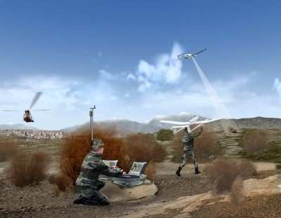
The DRAC can operate by day or night for up to 90 minutes and at
distances of more than 10 km from its user, transmitting in real
time the images and data it has gathered through the precision of a
miniaturized GPS code P(Y) receiver on board the UAV.
More News
Airport Marking Aids Markings used on runway and taxiway surfaces to identify a specific runway, a runway threshold, a centerline, a hold line, etc. A runway should be marked in ac>[...]
"It is extremely difficult, if not impossible, for manned aircraft to see a drone while conducting crop-enhancing and other aerial applications at low altitudes and high speeds. We>[...]
Aero Linx: The Skyhawk Association The Skyhawk Association is a non-profit organization founded by former Skyhawk Pilots which is open to anyone with an affinity for the A-4 Skyhaw>[...]
“The T-54A benefits from an active Beechcraft King Air assembly line in Wichita, Kansas, where all required METS avionics and interior modifications are installed on the line>[...]
Aero Linx: Aerostar Owners Association The Association offers the Aerostar Owner a unique opportunity to tap an invaluable source of information concerning the care and feeding of >[...]
 ANN's Daily Aero-Term (04.28.24): Airport Marking Aids

