Barbra Streisand Hits Aerial Photographer With $50 Million
Lawsuit
Thank God the constitution enables all citizens to exercise
their freedom of speech to say what they believe. That's what's
great about democracy and what's great about this country. - Barbra
Streisand, "My Thoughts On Freedom Of Speech," www.barbrastreisand.com
(posted March 24, 2003)
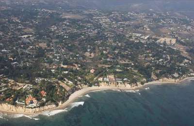
 The California Coastline Project, dedicated to
photographing the entire length of the left coast in sequence for
environmental purposes, finds itself crosswise with one of the most
vocal self-espoused environmentalists in America - singer Barbra
Streisand. Streisand is suing the non-profit organization, The
California Coastal Records Project, photographer Ken Adelman and
his associates for depriving her "of the economic value of the use
of the images of her property and residence." In other words, the
advocate of First Amendment Rights quoted at the top of this story
believes Adelman and his Robinson R-44, well off the coast (as can
be seen in the photographs below), has no right to shoot her little
slice of California.
The California Coastline Project, dedicated to
photographing the entire length of the left coast in sequence for
environmental purposes, finds itself crosswise with one of the most
vocal self-espoused environmentalists in America - singer Barbra
Streisand. Streisand is suing the non-profit organization, The
California Coastal Records Project, photographer Ken Adelman and
his associates for depriving her "of the economic value of the use
of the images of her property and residence." In other words, the
advocate of First Amendment Rights quoted at the top of this story
believes Adelman and his Robinson R-44, well off the coast (as can
be seen in the photographs below), has no right to shoot her little
slice of California.
Right To Privacy?
The lawsuit, filed May 20, 2003, says Streisand has plenty of
experience with "stalkers, threats to her safety, and undesirable
personalities." The photos of her home in Malibu, she says,
provides such undesirable people with a "roadmap" to her front
gate.
"The photographs of the Plaintiff's property and residence,
which Plaintiff (Streisand) believes were shot by Adelman from a
helicopter piloted by his wife flying overhead on the beach side of
the property, are extremely well-taken with equipment that reflects
the most cutting-edge visual technology," states Streisand's lawyer
in the lawsuit. "So much so, that the photographs of the
Plaintiff's property are shot at a very fine (high) resolution thus
showing details that would be impossible to see via the naked eye
while viewing from a public vantage point....
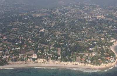
"Moreover," the suit continues, "the web site identifies the
property location by its longitudinal and latitudinal coordinates
and by showing its location on a map, and names the home the
"Streisand Estate, Malibu.... The clarity with which the details of
her private residence are paraded on the World Wide Web for all to
see has caused Plaintiff considerable anxiety."
"I think there's a free speech issue here," said Adelman, quoted
by the Associated Press. "The photographs were taken in a public
place where she doesn't have a reasonable expectation of
privacy."
A statement on the coastline project web site, www2.californiacoastline.org,
says, "We refuse to be intimidated by these tactics, which would
undermine our constitutional protection of free speech and which
would compromise the integrity of this historical and scientific
database."
Further, Susan Jordan, an Adelman supporter and non-profit
coastal volunteer, says "It's important for people to understand
that she's concerned about one frame out of 12,100 that includes
her property as well as others. Her house takes up roughly three
percent of the entire frame. In fact, it's not a photo of her
house. It's a photo of the California coastline, which happens to
include her property."
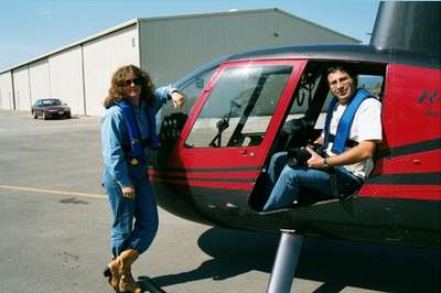
Adelman, a 39-year old Silicon Valley millionaire, takes the
pictures while his wife, Gabrielle, flies the R-44 (shown above).
The helicopter was flown southeast-bound along the coast at
altitudes ranging from 150 to 2000ft, but typically 500-700ft,
depending on the terrain, detail, and air traffic control
constraints. The port-side rear door was removed, giving the
photographer an unobstructed view of the coast.
The camera is hand-held to allow Adelman to correct for the
motion of the helicopter. The image frames are approximately
half-overlapping, meaning the shutter was depressed when the image
had moved halfway across the viewfinder. For various reasons, we
made more than one pass over certain areas. A sort algorithm is
applied to the data to merge the photographs from multiple passes
into a continuous coastline.
FMI: Threatening
Letter From Streisand's Lawyer, Streisand's
Lawsuit Against Aerial Photographer
 ANN's Daily Aero-Term (05.01.24): Say Altitude

