Thu, Oct 20, 2016
First Aerial Survey Speeds Cell Site Recovery To Just Hours
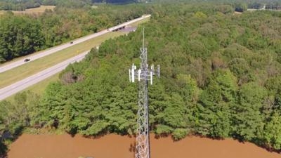
Verizon made use of drones to help with cell site inspections from the air in North Carolina and South Carolina to survey areas impacted by severe flooding from Hurricane Matthew. The quadcopter used for the inspections is an unmanned aerial system (UAS) operated by Measure UAS Inc., to inspect cell sites in difficult to reach locations and share vital information on any damaged equipment.
“We understand how vital wireless communication is to connect with loved ones, reach out for help and start the long process of recovery during and after an event like Hurricane Matthew,” said Nicki Palmer, Chief Network Officer. “While we were able to access most sites quickly to assess damage, some sites were not accessible to us due to extreme flooding. We are very pleased that we now have this new tool to add to our already extensive list of preparatory and recovery efforts to help inspect our network assets and expedite recovery time.”
The UAS is able to both record and livestream HD video and high-resolution photographs of a cell site. The first flight to a site surrounded by water near Elm City, N.C. and the Tar River Reservoir showed engineers that the base station equipment – which was elevated on stilts – was not underwater and had not suffered visible damage.
After determining the site was safe to access, Verizon’s Network team secured an airboat and refueled the generator, bringing the site back into service within hours.
Verizon completed successful cell site inspection trials earlier this year in New Jersey providing valuable 3-D imagery and system performance data via UAS/drone. Now the company has several vendors to aid Verizon’s network maintenance and operations. Measure is operating these flights with FAA authorization and uses a two-person crew that includes a ground pilot for the UAS and a visual observer of the operation for safe, legal and insured operations.
More recently, Verizon conducted the first ever trial with Verizon’s Airborne LTE Operations (ALO) during an emergency management and disaster recovery exercise in Cape May, N.J. The exercise simulated how Verizon’s Network can provide 4G LTE coverage from a 17-foot wingspan unmanned aircraft system, operated by American Aerospace Technologies, Inc. (AATI), to first responders in an area impacted by a severe weather event where no wireless service is available. While this is the first simulation in an emergency scenario, AATI and Verizon are conducting trials nationally testing connectivity between manned & unmanned aircraft and Verizon’s 4G LTE network including in-flight connectivity.
(Image provided with Verizon news release)
More News
Say Altitude Used by ATC to ascertain an aircraft's specific altitude/flight level. When the aircraft is climbing or descending, the pilot should state the indicated altitude round>[...]
Aero Linx: European Air Law Association (EALA) EALA was established in 1988 with the aim to promote the study of European air law and to provide an open forum for those with an int>[...]
From 2023 (YouTube Version): The Life, Death, Life, Death, and Life of a Glorious Warbird In 1981, business-owner Jim Tobul and his father purchased a Chance-Vought F4U Corsair. Mo>[...]
Also: USCG Retires MH-65 Dolphins, Irish Aviation Authority, NATCA Warns FAA, Diamond DA42 AD This summer, history enthusiasts will have a unique opportunity to experience World Wa>[...]
Also: WACO Kitchen Bails, French SportPlane Mfr to FL, Dynon-Advance Flight Systems, Innovation Preview Bobby Bailey, a bit of a fixture in sport aviation circles for his work with>[...]
 ANN's Daily Aero-Term (05.01.24): Say Altitude

