Central Michigan University Conducts Great Lakes Research With UAV Helo | Aero-News Network
Aero-News Network
RSS icon RSS feed
podcast icon MP3 podcast
Subscribe Aero-News e-mail Newsletter Subscribe

Airborne Unlimited -- Most Recent Daily Episodes

Episode Date

Airborne-Monday

Airborne-Tuesday

Airborne-Wednesday Airborne-Thursday

Airborne-Friday

Airborne On YouTube

Airborne-Unlimited-05.13.24

Airborne-NextGen-05.14.24

Airborne-Unlimited-05.15.24 Airborne-AffordableFlyers-05.16.24

Airborne-Unlimited-05.17.24

Tue, Feb 04, 2014

Central Michigan University Conducts Great Lakes Research With UAV Helo

Aircraft Equipped With Hyperspectral Camera Will Assist In Identification Of Invasive Wetland Species

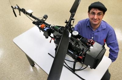
Central Michigan University has acquired the only unmanned aerial vehicle in Michigan — a six-foot long helicopter — equipped with a hyperspectral camera that will significantly advance research imaging of Great Lakes wetlands. The camera takes extremely high-resolution images in 334 colors compared to typical cameras that capture just three. (Think of the red, green and blue color sliders in Photoshop or iPhoto — then imagine 334 sliders.)

Researchers will use the semi-autonomous helicopter, controlled via computer or by radio waves, to capture images of vegetation in wetlands throughout the Great Lakes basin.  Their work will continue the fight against invasive species, protect rare plants and ultimately help to preserve and protect the world’s largest supply of fresh water.

“This allows us to determine where and when we collect the data instead of relying on archives from the federal government or commercial vendors,” said Benjamin Heumann, director of CMU’s Center for Geographic Information Science. The center conducts research locally, regionally and internationally on social and environmental issues that require spatial analysis.

“We now have the technology to do more than anyone else in the state in geomapping and analysis of wetland ecosytems,” Heumann said. “Using the hyperspectral camera, we have the capability to collect aerial imagery with far greater precision than manned aircraft and satellite.”

Now, instead of capturing an image that shows a tree, for example, the hyperspectral camera will show individual plant leaves throughout a wetland.

The helicopter flies at about 10 miles an hour and to the height of a 40-story building. It is flown under FAA guidelines.

The technology also has applications in agriculture. Heumann recently spoke at the Michigan Advanced Aerial System Consortium about the potential use of UAVs for mapping disease, detecting weeds and monitoring fertilization and drought in the state’s $5.72 billion field crops industry. “We can help farmers better forecast crop yields,” Heumann said. “By mapping disease, we can pinpoint more precisely where to target the spraying of pesticides, reducing costs to farmers and health hazards to humans and the environment.”

Heumann and a team of graduate students will use the helicopter for the first time this spring to determine the biodiversity of a wetland area in Washtenaw County.

The unmanned aerial vehicle and the hyperspectral camera were purchased by the College of Science and Technology at a cost of $140,000.

(Uncaptioned image from Central Michigan University news release)

FMI: www.cmich.edu

Advertisement

More News

Classic Aero-TV: Remembering Bob Hoover

From 2023 (YouTube Version): Legacy of a Titan Robert (Bob) Anderson Hoover was a fighter pilot, test pilot, flight instructor, and air show superstar. More so, Bob Hoover was an i>[...]

ANN FAQ: Follow Us On Instagram!

Get The Latest in Aviation News NOW on Instagram Are you on Instagram yet? It's been around for a few years, quietly picking up traction mostly thanks to everybody's new obsession >[...]

ANN's Daily Aero-Linx (05.15.24)

Aero Linx: B-52H Stratofortress The B-52H Stratofortress is a long-range, heavy bomber that can perform a variety of missions. The bomber is capable of flying at high subsonic spee>[...]

ANN's Daily Aero-Term (05.15.24):Altimeter Setting

Altimeter Setting The barometric pressure reading used to adjust a pressure altimeter for variations in existing atmospheric pressure or to the standard altimeter setting (29.92).>[...]

Aero-News: Quote of the Day (05.16.24)

"Knowing that we play an active part in bettering people's lives is extremely rewarding. My team and I are very thankful for the opportunity to be here and to help in any way we ca>[...]

blog comments powered by Disqus


Advertisement

Advertisement

Podcasts

Advertisement

© 2007 - 2024 Web Development & Design by Pauli Systems, LC