UAS Gives Scientists 3D View Of Atmosphere | Aero-News Network
Aero-News Network
RSS icon RSS feed
podcast icon MP3 podcast
Subscribe Aero-News e-mail Newsletter Subscribe

Airborne Unlimited -- Most Recent Daily Episodes

Episode Date

Airborne-Monday

Airborne-Tuesday

Airborne-Wednesday Airborne-Thursday

Airborne-Friday

Airborne On YouTube

Airborne-Unlimited-04.29.24

Airborne-NextGen-04.30.24

Airborne-Unlimited-05.01.24 Airborne-AffordableFlyers--05.02.24

Airborne-Unlimited-05.03.24

Mon, Jan 11, 2010

UAS Gives Scientists 3D View Of Atmosphere

Trio Of Aircraft Used In Climate Research

Scientists at Scripps Institution of Oceanography at UC San Diego have been using a fleet of Manta autonomous UAVs to track pollution and atmospheric data over the skies of Southern California.  The California AUAV Air Pollution Profiling Study (CAPPS) program is the latest in a series of science missions using UAS around the world.

The CAPPS began data collection on April 2, gathering a suite of meteorological data as they fly through clouds and aerosol masses in Southern California skies. When flying in formation, the aircraft can provide researchers with a unique three-dimensional view of atmospheric composition.

Miniaturized instruments on the aircraft, which typically flew in formations of three, measured a range of properties such as the quantity and size of the aerosols on which cloud droplets form. The instruments also recorded variables such as temperature, humidity and the intensity of light that permeates clouds and masses of smog. These comprehensive measurements were made at a very low cost when compared to traditional manned flights.


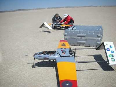
Technicians prepare the Manta for launch at Edwards AFB.

The Manta is one of several UAS produced by Advanced Ceramics Research in Tucson, AZ, now a part of BAE Systems.  Manta can carry a 15-lb payload for up to 6 hrs with a typical service altitude of 2,000-12,000 ft.  The aircraft have been deploying from NASA's Dryden Flight Research Center at Edwards AFB

Scripps researches hope to fly the system at least once a month to monitor Southern CA skies.  Future applications include real-time situational awareness during forest fires.

FMI: www.ARCTucson.com, sio.ucsd.edu

Advertisement

More News

ANN's Daily Aero-Term (05.01.24): Say Altitude

Say Altitude Used by ATC to ascertain an aircraft's specific altitude/flight level. When the aircraft is climbing or descending, the pilot should state the indicated altitude round>[...]

ANN's Daily Aero-Linx (05.01.24)

Aero Linx: European Air Law Association (EALA) EALA was established in 1988 with the aim to promote the study of European air law and to provide an open forum for those with an int>[...]

Classic Aero-TV: Korean War Hero Twice Reborn

From 2023 (YouTube Version): The Life, Death, Life, Death, and Life of a Glorious Warbird In 1981, business-owner Jim Tobul and his father purchased a Chance-Vought F4U Corsair. Mo>[...]

Airborne 04.29.24: EAA B-25 Rides, Textron 2024, G700 Deliveries

Also: USCG Retires MH-65 Dolphins, Irish Aviation Authority, NATCA Warns FAA, Diamond DA42 AD This summer, history enthusiasts will have a unique opportunity to experience World Wa>[...]

Airborne Affordable Flyers 05.02.24: Bobby Bailey, SPRG Report Cards, Skydive!

Also: WACO Kitchen Bails, French SportPlane Mfr to FL, Dynon-Advance Flight Systems, Innovation Preview Bobby Bailey, a bit of a fixture in sport aviation circles for his work with>[...]

blog comments powered by Disqus


Advertisement

Advertisement

Podcasts

Advertisement

© 2007 - 2024 Web Development & Design by Pauli Systems, LC