NOAA Finalizes 'Graphic Forecasts For Aviation' | Aero-News Network
Aero-News Network
RSS icon RSS feed
podcast icon MP3 podcast
Subscribe Aero-News e-mail Newsletter Subscribe

Airborne Unlimited -- Most Recent Daily Episodes

Episode Date

Airborne-Monday

Airborne-Tuesday

Airborne-Wednesday Airborne-Thursday

Airborne-Friday

Airborne On YouTube

Airborne-Unlimited-04.29.24

Airborne-NextGen-04.30.24

Airborne-Unlimited-05.01.24 Airborne-AffordableFlyers--05.02.24

Airborne-Unlimited-05.03.24

Tue, Apr 18, 2017

NOAA Finalizes 'Graphic Forecasts For Aviation'

Experimental Weather Product Now Operational

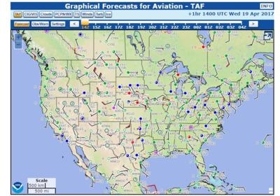
The National Oceanic and Atmospheric Administration (NOAA) has upgraded its experimental "Graphic Forecasts for Aviation" (GFA) to operational status as of Saturday. The new product is accepted by the FAA for weather briefings.

According to NOAA, the Graphical Forecasts for Aviation (GFA) web page is intended to provide the necessary aviation weather information to give users a complete picture of the weather that may impact flight in the continental United States (CONUS). The web page includes observational data, forecasts, and warnings that can be viewed from 14 hours in the past to 15 hours in the future, including thunderstorms, clouds, flight category, precipitation, icing, turbulence and wind. Hourly model data and forecasts, including information on clouds, flight category, precipitation, icing, turbulence, wind, and graphical output from the National Weather Service’s National Digital Forecast Data (NDFD), are available.

Wind, icing and turbulence forecasts are available in 3,000 ft. increments from the surface up to 30,000 ft. MSL, and in 6,000 ft. increments from 30,000 MSL to FL480 (48,000 ft. MSL). Turbulence forecasts are also broken into LO (below 18,000 MSL) and HI (at or above 18,000 MSL) graphics.

A maximum icing graphic and maximum wind velocity graphic (regardless of altitude) are also available. Built with modern geospatial information tools, users can pan and zoom to focus on areas of greatest interest.

The majority of the weather elements contained in the FA are already available through existing NWS products, NOAA says. To maintain continuity of service, the GFA will ensure the availability of equivalent information in addition to adding graphical displays of the predominant weather, sky cover, and wind speed and direction.

(Source: NOAA)

FMI: http://aviationweather.ncep.noaa.gov/gfa
 

Advertisement

More News

ANN's Daily Aero-Term (05.01.24): Say Altitude

Say Altitude Used by ATC to ascertain an aircraft's specific altitude/flight level. When the aircraft is climbing or descending, the pilot should state the indicated altitude round>[...]

ANN's Daily Aero-Linx (05.01.24)

Aero Linx: European Air Law Association (EALA) EALA was established in 1988 with the aim to promote the study of European air law and to provide an open forum for those with an int>[...]

Classic Aero-TV: Korean War Hero Twice Reborn

From 2023 (YouTube Version): The Life, Death, Life, Death, and Life of a Glorious Warbird In 1981, business-owner Jim Tobul and his father purchased a Chance-Vought F4U Corsair. Mo>[...]

Airborne 04.29.24: EAA B-25 Rides, Textron 2024, G700 Deliveries

Also: USCG Retires MH-65 Dolphins, Irish Aviation Authority, NATCA Warns FAA, Diamond DA42 AD This summer, history enthusiasts will have a unique opportunity to experience World Wa>[...]

Airborne Affordable Flyers 05.02.24: Bobby Bailey, SPRG Report Cards, Skydive!

Also: WACO Kitchen Bails, French SportPlane Mfr to FL, Dynon-Advance Flight Systems, Innovation Preview Bobby Bailey, a bit of a fixture in sport aviation circles for his work with>[...]

blog comments powered by Disqus


Advertisement

Advertisement

Podcasts

Advertisement

© 2007 - 2024 Web Development & Design by Pauli Systems, LC