SmarTopo Harvest Develops A 'Safe Zone' For UAVS | Aero-News Network
Aero-News Network
RSS icon RSS feed
podcast icon MP3 podcast
Subscribe Aero-News e-mail Newsletter Subscribe

Airborne Unlimited -- Most Recent Daily Episodes

Episode Date

Airborne-Monday

Airborne-Tuesday

Airborne-Wednesday Airborne-Thursday

Airborne-Friday

Airborne On YouTube

Airborne-Unlimited-05.13.24

Airborne-NextGen-05.14.24

Airborne-Unlimited-05.15.24 Airborne-AffordableFlyers-05.16.24

Airborne-Unlimited-05.17.24

Tue, Mar 31, 2015

SmarTopo Harvest Develops A 'Safe Zone' For UAVS

New Obstacle Detection Technology For The SmarTopo Obstacle Management System

Rapid Imaging Software, Inc. introduced SmarTopo Harvest on Monday. This new technology is integrated into the SmarTopo Obstacle Management System. SmarTopo delivers obstacle survey and detection technology plus powerful data management tools for a complete obstacle management system. SmarTopo is certified by the FAA to a level 1B.

Mike Abernathy, Director of Development notes, “SmarTopo Harvest is the key for small commercial drones to operate safely in urban areas. This technology allows companies to create and maintain an obstacle database for their drone operations."

SmarTopo Harvest is the latest obstacle detection technology from Rapid Imaging Software. The software provides a fast and efficient method to detect undocumented obstacles and add new obstacles to a database.

  • Searches for obstacles – the height for the search is set by the analyst
  • Detected objects or structures may be compared to the FAA obstacle database
  • Estimates height of the objects or structures
  • Creates new obstacle for a proprietary database

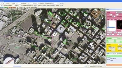
The issue of undocumented obstacles is extensive. A recent study conducted using SmarTopo Harvest indicates there are a substantial number of undocumented obstacles in the national airspace. An analyst using SmarTopo Harvest identified 52 undocumented obstacles of 200 feet or more in a study area of six square miles around the Los Angeles International Airport.

(Image provided by Rapid Imaging Software)

FMI: www.rapidimaging.net/obstaclemanagement/

Advertisement

More News

ANN's Daily Aero-Term (05.16.24): Instrument Runway

Instrument Runway A runway equipped with electronic and visual navigation aids for which a precision or nonprecision approach procedure having straight-in landing minimums has been>[...]

ANN's Daily Aero-Linx (05.16.24)

Aero Linx: Alaska Airmen's Association The Alaska Airmen's Association includes over 2,000 members—we are one of the largest General Aviation communities in the country. We s>[...]

Airborne 05.15.24: Ghost Sq MidAir, B-2 Junked, Dream Chaser Readies

Also: Flt School Security, G600 Steep-Approach, Honduran Aid, PW545D Cert Two aircraft performing at the Fort Lauderdale Air Show clipped wings during a routine last Sunday, spooki>[...]

Airborne 05.10.24: Icon Auction, Drunk MedEvac Pilot, Bell ALFA

Also: SkyReach Parts Support, Piper Service Ctr, Airliner Near-Miss, Airshow London The Judge overseeing Icon's convoluted Chapter 11 process has approved $9 million in Chapter 11 >[...]

Airborne Affordable Flyers 05.16.24: PRA Runway, Wag-Aero Sold, Young Eagles

Also: Paramotor Champ's, Electric Ultralight, ICON BK Update, Burt Rutan at Oshkosh! The Popular Rotorcraft Association is reaching out for help in rebuilding their private runway >[...]

blog comments powered by Disqus


Advertisement

Advertisement

Podcasts

Advertisement

© 2007 - 2024 Web Development & Design by Pauli Systems, LC