GPS In The Southeast May Be Inaccurate Or Unavailable During Testing | Aero-News Network
Aero-News Network
RSS icon RSS feed
podcast icon MP3 podcast
Subscribe Aero-News e-mail Newsletter Subscribe

Airborne Unlimited -- Most Recent Daily Episodes

Episode Date

Airborne-Monday

Airborne-Tuesday

Airborne-Wednesday Airborne-Thursday

Airborne-Friday

Airborne On YouTube

Airborne-Unlimited-04.29.24

Airborne-Unlimited-04.23.24

Airborne-Unlimited-04.24.24 Airborne-FltTraining-04.25.24

Airborne-Unlimited-04.26.24

Thu, Jan 20, 2011

GPS In The Southeast May Be Inaccurate Or Unavailable During Testing

Evaluation Of System Centered Off The Georgia Coast

The Department of Defense will conduct GPS tests on January 20th through February 22nd, 2011. During testing, the GPS signal may be unreliable or unavailable.

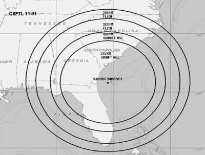
The testing will be centered at 304906N/0802811W or the location know as 105.25 degrees and 52.1 NM from the SSI VOR. GPS testing is scheduled on January 20th through February 11th, 2011 from 0000-0245 UTC daily and February 15th through February 22nd, 2011 from 0000-0245 UTC daily. These tests may not be concurrent so pilots are advised to check NOTAMS frequently for possible changes prior to operating in the area.

Several test events will be conducted and will be active for 45 minutes followed by 15 minutes of off time. During testing, GPS will be unreliable and may be unavailable with in a circle with a radius of 370NM and centered at 304906N/0802811W or the location known as 105.25 degrees and 52.1 NM from the SSI VOR at FL400; decreasing in area with a decrease in altitude to a circle with a radius of 325NM at FL250; a circle with a radius of 260NM at 10,000FT MSL and a circle with a radius of 215NM at 4,000FT AGL.

Pilots are highly recommended to report anomalies during testing to the appropriate ARTCC to assist in the determination of the extent of GPS  degradation during tests. The NOTAMs discussed in this advisory may change with little or no notice. Pilots are advised to check NOTAMs frequently for possible changes prior to operations in the area. NOTAMs will be published at least 24 hours in advance of any GPS tests.

FMI: www.faa.gov

Advertisement

More News

Unfortunate... ANN/SportPlane Resource Guide Adds To Cautionary Advisories

The Industry Continues to be Rocked By Some Questionable Operations Recent investigations and a great deal of data has resulted in ANN’s SportPlane Resource Guide’s rep>[...]

ANN FAQ: Turn On Post Notifications

Make Sure You NEVER Miss A New Story From Aero-News Network Do you ever feel like you never see posts from a certain person or page on Facebook or Instagram? Here’s how you c>[...]

ANN's Daily Aero-Term (04.29.24): Visual Approach Slope Indicator (VASI)

Visual Approach Slope Indicator (VASI) An airport lighting facility providing vertical visual approach slope guidance to aircraft during approach to landing by radiating a directio>[...]

ANN's Daily Aero-Term (04.28.24): Airport Marking Aids

Airport Marking Aids Markings used on runway and taxiway surfaces to identify a specific runway, a runway threshold, a centerline, a hold line, etc. A runway should be marked in ac>[...]

ANN's Daily Aero-Linx (04.28.24)

Aero Linx: The Skyhawk Association The Skyhawk Association is a non-profit organization founded by former Skyhawk Pilots which is open to anyone with an affinity for the A-4 Skyhaw>[...]

blog comments powered by Disqus


Advertisement

Advertisement

Podcasts

Advertisement

© 2007 - 2024 Web Development & Design by Pauli Systems, LC