Thu, Jul 21, 2005
Rockwell Collins Completes Successful SE-Vision Test
Flights
 Rockwell Collins' SE-Vision program
has reached a new milestone by successfully completing military and
commercial test flights in New Mexico and New Jersey in June.
SE-Vision flight deck technology, which integrates synthetic vision
generated scenes with real-time enhanced vision imagery, is being
developed by Rockwell Collins in collaboration with the Federal
Aviation Administration (FAA), the Air Force Research Lab (AFRL),
NASA Langley Research Center and Max-Viz.
Rockwell Collins' SE-Vision program
has reached a new milestone by successfully completing military and
commercial test flights in New Mexico and New Jersey in June.
SE-Vision flight deck technology, which integrates synthetic vision
generated scenes with real-time enhanced vision imagery, is being
developed by Rockwell Collins in collaboration with the Federal
Aviation Administration (FAA), the Air Force Research Lab (AFRL),
NASA Langley Research Center and Max-Viz.
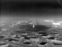 The SE-Vision program flight tests
demonstrated concepts for sensor and synthetic imagery for use by
the US Air Force's mobility operations in a low altitude tactical
environment. The flights were conducted through June on the FAA
William J. Hughes Technical Center's Boeing 727-100 which was
equipped with Rockwell Collins HGS-4000 Heads-Up Guidance System
(HGSTM), Max-Viz Dual Band Infrared Sensors, Rockwell Collins
MultiScan Hazard Weather Detection System and an LCD head-down
display (HDD). SE-Vision display and guidance concepts were shown
on both the HUD and the HDD.
The SE-Vision program flight tests
demonstrated concepts for sensor and synthetic imagery for use by
the US Air Force's mobility operations in a low altitude tactical
environment. The flights were conducted through June on the FAA
William J. Hughes Technical Center's Boeing 727-100 which was
equipped with Rockwell Collins HGS-4000 Heads-Up Guidance System
(HGSTM), Max-Viz Dual Band Infrared Sensors, Rockwell Collins
MultiScan Hazard Weather Detection System and an LCD head-down
display (HDD). SE-Vision display and guidance concepts were shown
on both the HUD and the HDD.
"SE-Vision provides a visualization solution for pilots who are
required to fly in low visibility conditions and unfamiliar
territory," said Tim Etherington, principal systems engineer at
Rockwell Collins Advanced Technology Center. "This technology can
have a major impact on the success of special operations missions
in the military, and provide promising opportunities for civil
aviation as well."
"The combination of synthetic vision and sensor technologies
will allow USAF mobility operations to operate independently of
visibility with improved situation awareness and safety," said Guy
French, SE-Vision Government Program Manager, AFRL.
 The demonstration flights took place
on a practice route used by Kirtland Air Force Base in New Mexico
for low level training. The routes used SE-Vision technology to
guide the aircraft through a mountain range at a pilot selected
altitude of 650 feet above the terrain for this flight test. Ten
Air Force pilots flew the terrain following path using SE-Vision
technology. A simulated version of the terrain following route was
demonstrated out of the William J. Hughes Technical Center in
Atlantic City, NJ.
The demonstration flights took place
on a practice route used by Kirtland Air Force Base in New Mexico
for low level training. The routes used SE-Vision technology to
guide the aircraft through a mountain range at a pilot selected
altitude of 650 feet above the terrain for this flight test. Ten
Air Force pilots flew the terrain following path using SE-Vision
technology. A simulated version of the terrain following route was
demonstrated out of the William J. Hughes Technical Center in
Atlantic City, NJ.
More News
Airport Marking Aids Markings used on runway and taxiway surfaces to identify a specific runway, a runway threshold, a centerline, a hold line, etc. A runway should be marked in ac>[...]
"It is extremely difficult, if not impossible, for manned aircraft to see a drone while conducting crop-enhancing and other aerial applications at low altitudes and high speeds. We>[...]
Aero Linx: The Skyhawk Association The Skyhawk Association is a non-profit organization founded by former Skyhawk Pilots which is open to anyone with an affinity for the A-4 Skyhaw>[...]
“The T-54A benefits from an active Beechcraft King Air assembly line in Wichita, Kansas, where all required METS avionics and interior modifications are installed on the line>[...]
Aero Linx: Aerostar Owners Association The Association offers the Aerostar Owner a unique opportunity to tap an invaluable source of information concerning the care and feeding of >[...]
 ANN's Daily Aero-Term (04.28.24): Airport Marking Aids

