Fri, Jul 14, 2006
 NOTAM Number: FDC 6/2585
Issue Date: July 13, 2006 at 18:09 UTC
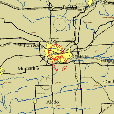
Location: Moline, Illinois
Beginning Date and Time: July 17, 2006 at 20:45 UTC
Ending Date and Time: July 18, 2006 at 0:10 UTC
Reason for NOTAM: Temporary flight restrictions for VIP (Very
Important Person) Movement
Type: VIP
Replaced NOTAM(s): N/A
Affected Area(s)
Area A
Airspace Definition:
TFR Center: 9.7 nautical miles from MOLINE VORTAC(MZV) on the
033 radial (Latitude: 41º26'53"N, Longitude:
90º30'20"W)
Radius: 3 nautical miles
Altitude: From the surface up to but not including 3000 feet
AGL
Effective Date(s):
July 17, 2006 at 20:45 UTC (July 17, 2006 at 15:45 CDT) -
July 17, 2006 at 21:35 UTC (July 17, 2006 at 16:35 CDT)
Area B
Airspace Definition:
TFR Center: 11.1 nautical miles from DAVENPORT
VORTAC(CVA) on the 187 radial (Latitude: 41º31'35"N,
Longitude: 90º31'55"W)
Radius: 3 nautical miles
Altitude: From the surface up to but not including 3000 feet
AGL
Effective Date(s):
July 17, 2006 at 21:10 UTC (July 17, 2006 at 16:10 CDT) -
July 17, 2006 at 23:45 UTC (July 17, 2006 at 18:45 CDT)
Area C
Airspace Definition:
TFR Center: 9.7 nautical miles from MOLINE VORTAC(MZV) on the
033 radial (Latitude: 41º26'53"N, Longitude:
90º30'20"W)
Radius: 3 nautical miles
Altitude: From the surface up to but not including 3000 feet
AGL
Effective Date(s):
July 17, 2006 at 23:20 UTC (July 17, 2006 at 18:20 CDT) -
July 18, 2006 at 0:10 UTC (July 17, 2006 at 19:10 CDT)
Operating Restrictions and Requirements
No pilots may operate an aircraft in the areas covered by this
NOTAM (except as described).
Unless otherwise authorized by ATC in consultation with
the Domestic Events Network (DEN).
Other Information:
ARTCC: ZAU - Chicago Center
Authority: Title 14 CFR section 91.141
FMI: www.tfr.faa.gov,
Depicted TFR data may not be a complete listing. Pilots should not
use the information on this website for flight planning purposes.
For the latest information, call your local Flight Service Station
at 1-800-WX-BRIEF.
More News
Airport Marking Aids Markings used on runway and taxiway surfaces to identify a specific runway, a runway threshold, a centerline, a hold line, etc. A runway should be marked in ac>[...]
"It is extremely difficult, if not impossible, for manned aircraft to see a drone while conducting crop-enhancing and other aerial applications at low altitudes and high speeds. We>[...]
Aero Linx: The Skyhawk Association The Skyhawk Association is a non-profit organization founded by former Skyhawk Pilots which is open to anyone with an affinity for the A-4 Skyhaw>[...]
“The T-54A benefits from an active Beechcraft King Air assembly line in Wichita, Kansas, where all required METS avionics and interior modifications are installed on the line>[...]
Aero Linx: Aerostar Owners Association The Association offers the Aerostar Owner a unique opportunity to tap an invaluable source of information concerning the care and feeding of >[...]
 ANN's Daily Aero-Term (04.28.24): Airport Marking Aids

