Year-Long Mission Yields Detailed Lunar Map, New Environmental
Data
 NASA's Lunar Reconnaissance Orbiter, or LRO, completed the
exploration phase of its mission on Wednesday.
NASA's Lunar Reconnaissance Orbiter, or LRO, completed the
exploration phase of its mission on Wednesday.
LRO completed a one-year exploration mission in a polar orbit
approximately 31 miles above the moon's surface. It produced a
comprehensive map of the lunar surface in unprecedented detail;
searched for resources and safe landing sites for potential future
missions to the moon; and measured lunar temperatures and radiation
levels.
The mission is turning its attention from exploration objectives
to scientific research, as program management moves from NASA's
Exploration Systems Mission Directorate to the Science Mission
Directorate at the agency's Headquarters in Washington.
"LRO has been an outstanding success. The spacecraft has
performed brilliantly," said Doug Cooke, associate administrator of
the Exploration Systems Mission Directorate. "LRO's science and
engineering teams achieved all of the mission's objectives, and the
incredible data LRO gathered will provide discoveries about the
moon for years to come."
The LRO team will continue to send data gathered during the last
year to the Planetary Data System, which archives and distributes
scientific information from NASA planetary missions, astronomical
observations and laboratory measurements.
By the time LRO achieves full mission success in March, and its
data is processed and released to the scientific community, it will
have sent more information to the Planetary Data System than all
other previous planetary missions combined. During its new phase of
discovery, LRO will continue to map the moon for two to four more
years.
"The official start of LRO's science phase should write a new
and intriguing chapter in lunar research," said Ed Weiler,
associate administrator for the Science Mission Directorate. "This
mission is one more asset added to NASA's vast science
portfolio."
The spacecraft launched from NASA's Kennedy Space Center in
Florida carrying a suite of seven instruments on June 18, 2009. LRO
formally began its detailed survey of the moon in September
2009.
Results from the mission include: new
observations of the Apollo landing sites; indications that
permanently shadowed and nearby regions may harbor water and
hydrogen; observations that large areas in the permanently shadowed
regions are colder than Pluto; detailed information about lunar
terrain; and the first evidence of a globally distributed
population of thrust faults that indicates the moon has recently
contracted and may still be shrinking.
LRO also took high resolution pictures of the Lunokhod 1 rover
that had been lost for almost 40 years. The rover, which carries a
retroreflector, was located to within approximately 150 feet. The
accurate position data enabled researchers on Earth to bounce laser
signals off the retroreflector for the first time ever. The
retroreflector is providing important new information about the
position and motion of the moon.
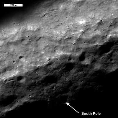
LRO Image of Lunar South Pole/NASA PHOTO
LRO also supported the Lunar Crater Observation and Sensing
Satellite impact, a companion mission sent to determine if the
moon's poles harbor water ice, by helping to select a promising
impact site. LRO observed both the expanding plume that arose after
the impact and the evolving temperature at the site.
NASA's Goddard Space Flight Center in Greenbelt, MD, built and
manages LRO for the Exploration Systems Mission Directorate. The
Institute for Space Research in Moscow provides the neutron
detector aboard the spacecraft.
 ANN's Daily Aero-Linx (05.04.24)

