Global Hawk Collects Recon Data During Haiti Relief Efforts | Aero-News Network
Aero-News Network
RSS icon RSS feed
podcast icon MP3 podcast
Subscribe Aero-News e-mail Newsletter Subscribe

Airborne Unlimited -- Most Recent Daily Episodes

Episode Date

Airborne-Monday

Airborne-Tuesday

Airborne-Wednesday Airborne-Thursday

Airborne-Friday

Airborne On YouTube

Airborne-Unlimited-04.29.24

Airborne-Unlimited-04.23.24

Airborne-Unlimited-04.24.24 Airborne-FltTraining-04.25.24

Airborne-Unlimited-04.26.24

Wed, Jan 20, 2010

Global Hawk Collects Recon Data During Haiti Relief Efforts

Helping Determine The Extent Of Damage, Locate Potential Airfields

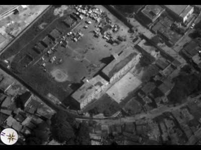
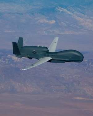
An RQ-4 Global Hawk is providing imagery to determine the extent of damage to earthquake-stricken Haiti and usability of its infrastructure, an Air Force official said during a Department of Defense Bloggers Roundtable January 15. "A lot of images of destroyed buildings," said Col. Bradley G. Butz, the 480th Intelligence, Surveillance and Reconnaissance Wing vice commander.


Photo Courtesy U.S. Air Force

They are looking at images of airports to find airfields to land aircraft, he added. The image quality and clarity is good enough whether or not an airfield can accept aircraft. "We've got pretty good coverage of the entire country of Haiti," Colonel Butz said.

The Global Hawk is a high-altitude, long-endurance unmanned aircraft with an integrated sensor suite that provides worldwide ISR capability.

The 480th ISR, based at Langley Air Force Base, VA, is providing its images to U.S. Southern Command officials for use by whomever needs the images, Colonel Butz said. The objective is mass distribution to people and organizations that need the images to support relief and recovery operations.

These images can help determine the level of destruction since aerial images of Haiti exist from June 2009. Comparing the June 2009 and the January 2010 can give an indication of the extent of the disaster. Without context "we just don't know the impact," the colonel said.

In addition, the Global Hawk provides assistance to Soldiers of the 82nd Airborne Division who are deploying to Haiti. The Global Hawk is providing images of where the Soldiers are deploying to help them prepare for their mission, Colonel Butz said.


File Photo

The Global Hawk flew 14 hours January 14, providing between 400 to 700 images, the colonel said. It is flying daily out of Naval Air Station Patuxent River, MD. The colonel said the Global Hawk will continue providing Haitian overflight support as long as the president requests.

This is the first use of the Global Hawk in a disaster relief mission in the Caribbean, according to the colonel.

FMI: www.af.mil

Advertisement

More News

ANN's Daily Aero-Term (04.28.24): Airport Marking Aids

Airport Marking Aids Markings used on runway and taxiway surfaces to identify a specific runway, a runway threshold, a centerline, a hold line, etc. A runway should be marked in ac>[...]

Aero-News: Quote of the Day (04.28.24)

"It is extremely difficult, if not impossible, for manned aircraft to see a drone while conducting crop-enhancing and other aerial applications at low altitudes and high speeds. We>[...]

ANN's Daily Aero-Linx (04.28.24)

Aero Linx: The Skyhawk Association The Skyhawk Association is a non-profit organization founded by former Skyhawk Pilots which is open to anyone with an affinity for the A-4 Skyhaw>[...]

Aero-News: Quote of the Day (04.29.24)

“The T-54A benefits from an active Beechcraft King Air assembly line in Wichita, Kansas, where all required METS avionics and interior modifications are installed on the line>[...]

ANN's Daily Aero-Linx (04.29.24)

Aero Linx: Aerostar Owners Association The Association offers the Aerostar Owner a unique opportunity to tap an invaluable source of information concerning the care and feeding of >[...]

blog comments powered by Disqus


Advertisement

Advertisement

Podcasts

Advertisement

© 2007 - 2024 Web Development & Design by Pauli Systems, LC