Imaging Clouds, Sea Surface Temps, Smoke Plumes, All In Living Color | Aero-News Network
Aero-News Network
RSS icon RSS feed
podcast icon MP3 podcast
Subscribe Aero-News e-mail Newsletter Subscribe

Airborne Unlimited -- Most Recent Daily Episodes

Episode Date

Airborne-Monday

Airborne-Tuesday

Airborne-Wednesday Airborne-Thursday

Airborne-Friday

Airborne On YouTube

Airborne-Unlimited-04.29.24

Airborne-Unlimited-04.23.24

Airborne-Unlimited-04.24.24 Airborne-FltTraining-04.25.24

Airborne-Unlimited-04.26.24

Thu, Apr 29, 2010

Imaging Clouds, Sea Surface Temps, Smoke Plumes, All In Living Color

New Weather Satellite Captures Its First Thermal Images Of Earth

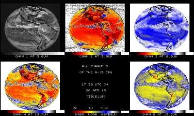
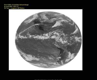
GOES-15, the final spacecraft in the latest series of NOAA geostationary satellites, took its first infrared image of Earth on April 26.


Image Courtesy NOAA

GOES spacecraft help NOAA forecasters track dangerous weather conditions and solar activity that can impact the satellite-based electronics and communications industry.

Infrared imagery is critical for accurate weather forecasts, revealing a range of information -- from the swirling motion of clouds and sea-surface temperatures, to moisture profiles of the atmosphere and the movement of smoke plumes from wildfires

GOES-15 was launched March 4, 2010, from Cape Canaveral, FL. After approximately five more months of tests, NASA will officially “hand over” the satellite to NOAA, which will place it in orbital storage mode. GOES-15 will be ready for activation if any of NOAA’s other four geostationary spacecraft experiences trouble.


Image Courtesy NOAA

NOAA works to understand and predict changes in the Earth’s environment, from the depths of the ocean, to the surface of the sun, and conserves and manages our coastal and marine resources.

FMI: www.noaa.gov

Advertisement

More News

Unfortunate... ANN/SportPlane Resource Guide Adds To Cautionary Advisories

The Industry Continues to be Rocked By Some Questionable Operations Recent investigations and a great deal of data has resulted in ANN’s SportPlane Resource Guide’s rep>[...]

ANN FAQ: Turn On Post Notifications

Make Sure You NEVER Miss A New Story From Aero-News Network Do you ever feel like you never see posts from a certain person or page on Facebook or Instagram? Here’s how you c>[...]

ANN's Daily Aero-Term (04.29.24): Visual Approach Slope Indicator (VASI)

Visual Approach Slope Indicator (VASI) An airport lighting facility providing vertical visual approach slope guidance to aircraft during approach to landing by radiating a directio>[...]

ANN's Daily Aero-Term (04.28.24): Airport Marking Aids

Airport Marking Aids Markings used on runway and taxiway surfaces to identify a specific runway, a runway threshold, a centerline, a hold line, etc. A runway should be marked in ac>[...]

ANN's Daily Aero-Linx (04.28.24)

Aero Linx: The Skyhawk Association The Skyhawk Association is a non-profit organization founded by former Skyhawk Pilots which is open to anyone with an affinity for the A-4 Skyhaw>[...]

blog comments powered by Disqus


Advertisement

Advertisement

Podcasts

Advertisement

© 2007 - 2024 Web Development & Design by Pauli Systems, LC