Drones Map A Major Canadian City For The First Time | Aero-News Network
Aero-News Network
RSS icon RSS feed
podcast icon MP3 podcast
Subscribe Aero-News e-mail Newsletter Subscribe

Airborne Unlimited -- Most Recent Daily Episodes

Episode Date

Airborne-Monday

Airborne-Tuesday

Airborne-Wednesday Airborne-Thursday

Airborne-Friday

Airborne On YouTube

Airborne-Unlimited-04.29.24

Airborne-NextGen-04.30.24

Airborne-Unlimited-05.01.24 Airborne-AffordableFlyers--05.02.24

Airborne-Unlimited-05.03.24

Fri, Jul 13, 2018

Drones Map A Major Canadian City For The First Time

Global UAV And InDro Robotics Conduct First Sanctioned UAV Mapping Missions

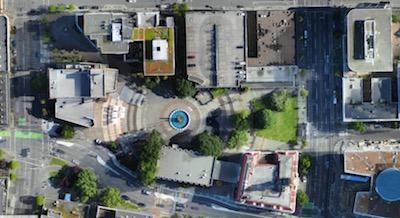
Global UAV Technologies, together with InDro Robotics Inc. (“InDro”), a compliant UAV mapping, training, and consulting business, and High Eye Aerial Imaging Inc. (“High Eye”), have concluded the first UAV mapping mission over a major Canadian metropolitan city. The first of its kind operation, flown over the downtown core of Victoria, B.C. on June 14th, 2018, was completed for the City of Victoria’s Emergency Management Division and conducted alongside members of Transport Canada.

Two flights were completed covering a 0.57 square mile area with approximately 1000 high resolution drone acquired images collected. The survey was completed in one day by a professional flight crew which included personnel from InDro Robotics, Global UAV Technologies Ltd., and High Eye Aerial Imaging Inc. The flight was conducted with a Sensefly eBee plus RTK/PPK UAV.

“This first of its kind operation signals a significant achievement for High Eye, InDro and Global UAV. The ability to safely operate a UAV over a populated downtown core without interrupting people’s daily commute is a milestone event and will aid in progressing UAV regulations in Canada. The successful collaboration between Global UAV, InDro Robotics, Transport Canada and the City of Victoria on the project provides a foundation for future collaborations on similar missions.” said Jeremy McCalla, Global UAV Technologies’ Business Development and Operations Manager.

“Transport Canada’s willingness to work with the team to ensure this mission, vital to emergency planning and preparedness, could be flown in an efficient and safe manner has provided not only a wealth of data for emergency response but also a new depth of knowledge for future operations in such environments.” stated Phillip Reece, CEO of InDro Robotics.

(Image provided with Global UAV news release)

FMI: www.globaluavtech.com

Advertisement

More News

ANN's Daily Aero-Linx (05.02.24)

Aero Linx: Model Aeronautical Association of Australia MAAA clubs are about fun flying, camaraderie and community. For over 75 years, the MAAA has been Australia’s largest fl>[...]

ANN's Daily Aero-Term (05.02.24): Touchdown Zone Lighting

Touchdown Zone Lighting Two rows of transverse light bars located symmetrically about the runway centerline normally at 100 foot intervals. The basic system extends 3,000 feet alon>[...]

Aero-News: Quote of the Day (05.02.24)

“Discovery and innovation are central to our mission at Virgin Galactic. We’re excited to build on our successful record of facilitating scientific experiments in subor>[...]

ANN FAQ: Contributing To Aero-TV

How To Get A Story On Aero-TV News/Feature Programming How do I submit a story idea or lead to Aero-TV? If you would like to submit a story idea or lead, please contact Jim Campbel>[...]

NTSB Final Report: Cirrus Design Corp SR20

Student Pilot Reported That During Rotation, “All Of A Sudden The Back Of The Plane Kicked To The Right..." Analysis: The student pilot reported that during rotation, “>[...]

blog comments powered by Disqus


Advertisement

Advertisement

Podcasts

Advertisement

© 2007 - 2024 Web Development & Design by Pauli Systems, LC