United Launch Alliance Launches GeoEye-1 Commercial Satellite | Aero-News Network
Aero-News Network
RSS icon RSS feed
podcast icon MP3 podcast
Subscribe Aero-News e-mail Newsletter Subscribe

Airborne Unlimited -- Most Recent Daily Episodes

Episode Date

Airborne-Monday

Airborne-Tuesday

Airborne-Wednesday Airborne-Thursday

Airborne-Friday

Airborne On YouTube

Airborne-Unlimited-04.29.24

Airborne-Unlimited-04.23.24

Airborne-Unlimited-04.24.24 Airborne-FltTraining-04.25.24

Airborne-Unlimited-04.26.24

Mon, Sep 08, 2008

United Launch Alliance Launches GeoEye-1 Commercial Satellite

59-Minute Trip To Orbit Followed By Successful Deployment

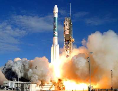
A United Launch Alliance Delta II rocket, on behalf of Boeing Launch Systems, successfully launched the GeoEye-1 satellite at 11:51 am PDT on Saturday. Blasting off from Space Launch Complex 2 at Vandenberg AFB, it marked the second ULA Delta II mission from Vandenberg in 2008.

GeoEye-1 will provide the highest resolution of any commercial imaging system -- 0.41-meters or 16 inches for panchromatic (black and white) imagery and multispectral (color) imagery at 1.65-meter resolution.

Following a nearly 59-minute flight, the GeoEye-1 spacecraft was deployed on its mission equipped with the most advanced and sophisticated technology, capable of offering three-meter accuracy. This allows end users to map natural and man-made features to within three meters of their actual locations on the surface of the Earth without ground control points.

"ULA is pleased to have successfully launched the GeoEye-1 satellite for our GeoEye and Boeing Launch Systems customers," said Jim Sponnick, ULA vice president, Delta Product Line. "We are excited to be part of the team that built and launched this advanced satellite technology, which will ultimately provide the highest-resolution view of our home planet ever available to scientists, businesses, the US government, and private citizens."

The ULA Delta II 7420-10 configuration vehicle featured a first stage booster powered by a Pratt & Whitney Rocketdyne RS-27A main engine and four Alliant Techsystems (ATK) strap-on solid rocket motors. An Aerojet AJ10-118K engine powered the second stage. The payload was encased by a 10-foot-diameter composite payload fairing. The vehicle guidance and navigation system for the Delta launch vehicles is provided by L-3 Space & Navigation's Redundant Inertial Flight Control Assembly (RIFCA).

"On behalf of the United Launch Alliance, I congratulate L-3 Communications on their outstanding achievement of the 100th consecutive successful RIFCA flight on this GeoEye-1 mission," said Sponnick. "Today's launch was a significant milestone for our L-3 partners after a long history of support to the Delta II, Delta III, and Delta IV vehicles."

ULA began assembling the Delta II launch vehicle in Decatur, AL nearly two years ago. In late May the first stage arrived at Vandenberg from Decatur, followed by the second stage in June. The vehicle was erected on the stand at SLC-2, July 3, with solid rocket motor installation completed by July 9. The GeoEye-1 spacecraft was mated to the Delta II booster August 7.

ULA's next launch is a National Reconnaissance office mission scheduled for October 17, from Cape Canaveral Air Force Station, FL aboard a Delta IV Heavy from SLC-37.

FMI: www.ulalaunch.com

Advertisement

More News

Unfortunate... ANN/SportPlane Resource Guide Adds To Cautionary Advisories

The Industry Continues to be Rocked By Some Questionable Operations Recent investigations and a great deal of data has resulted in ANN’s SportPlane Resource Guide’s rep>[...]

ANN FAQ: Turn On Post Notifications

Make Sure You NEVER Miss A New Story From Aero-News Network Do you ever feel like you never see posts from a certain person or page on Facebook or Instagram? Here’s how you c>[...]

ANN's Daily Aero-Term (04.29.24): Visual Approach Slope Indicator (VASI)

Visual Approach Slope Indicator (VASI) An airport lighting facility providing vertical visual approach slope guidance to aircraft during approach to landing by radiating a directio>[...]

ANN's Daily Aero-Term (04.28.24): Airport Marking Aids

Airport Marking Aids Markings used on runway and taxiway surfaces to identify a specific runway, a runway threshold, a centerline, a hold line, etc. A runway should be marked in ac>[...]

ANN's Daily Aero-Linx (04.28.24)

Aero Linx: The Skyhawk Association The Skyhawk Association is a non-profit organization founded by former Skyhawk Pilots which is open to anyone with an affinity for the A-4 Skyhaw>[...]

blog comments powered by Disqus


Advertisement

Advertisement

Podcasts

Advertisement

© 2007 - 2024 Web Development & Design by Pauli Systems, LC