Tue, Sep 24, 2019
Included Classroom Instruction And Hands-On Flights
Oceans Unmanned, Inc., in partnership with DARTDrones, recently trained seven NOAA ship officers and Navigation Response Team members on drone operations at the NOAA Marine Operations Center in Newport, OR. The successful two-day training included classroom instruction and hands-on flights focused on vessel-based research and mapping missions. Students practiced launch and recovery procedures, and programmed mapping missions from the deck of the NOAA Ship Hi‘ialakai while alongside the marine facility. This training is the first step to more broadly integrating drone operations for a variety of missions across the NOAA fleet.
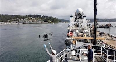
Students were trained and certified on the DJI Mavic and Phantom series, and introduced to the larger Matrice 210RTK drones. These systems have a proven, reliable track record for being user-friendly, and highly capable for ship and small boat launch and recovery. “We have multiple years of experience in vessel-based drone operations supporting missions including wildlife surveys, habitat mapping, shallow water shipwreck surveys, and more, and are excited to assist NOAA in utilizing these systems safely and efficiently.” said Brian Taggart, Chief Pilot of Oceans Unmanned. “These relatively inexpensive, off-the-shelf drones, have the capability to support a wide variety of ocean and coastal environmental research projects.”
NOAA is integrating small drones aboard their survey ships for near-shore and shoreline feature charting, by supporting or augmenting traditional shoreline verification and mapping techniques used by hydrographic survey field units. Potential benefits of using drones for this requirement include: improved data collection efficiency compared to data collection from small boats; more accurate feature investigation than traditional techniques; and, most importantly, removal of personnel from potentially dangerous situations.
The training was supported and funded by the NOAA National Geodetic Survey (NGS) Remote Sensing Division (RSD) which has been evaluating and operating drones for several years to meet coastal mapping requirements. “RSD has developed much of the internal policies, procedures, and protocols necessary for safe and effective drone field operations for mapping,” said Mike Aslaksen, Chief, NOAA Remote Sensing Division. “and we’re big supporters of getting this technology operational across the NOAA fleet.”
(Image provided with Oceans Unmanned news release)
More News
Hold Procedure A predetermined maneuver which keeps aircraft within a specified airspace while awaiting further clearance from air traffic control. Also used during ground operatio>[...]
Altitude Readout An aircraft’s altitude, transmitted via the Mode C transponder feature, that is visually displayed in 100-foot increments on a radar scope having readout cap>[...]
Aero Linx: European Hang Gliding and Paragliding Union (EHPU) The general aim of the EHPU is to promote and protect hang gliding and paragliding in Europe. In order to achieve this>[...]
Also: Skydio Chief, Uncle Sam Sues, Dash 7 magniX, OR UAS Accelerator US Secretary of the Air Force Frank Kendall was given a turn around the patch in the 'X-62A Variable In-flight>[...]
"The need for innovation at speed and scale is greater than ever. The X-62A VISTA is a crucial platform in our efforts to develop, test and integrate AI, as well as to establish AI>[...]
 ANN's Daily Aero-Term (05.09.24): Hold Procedure

