NTSB: Severe Icing Brought Down SR22 Last February | Aero-News Network
Aero-News Network
RSS icon RSS feed
podcast icon MP3 podcast
Subscribe Aero-News e-mail Newsletter Subscribe

Airborne Unlimited -- Most Recent Daily Episodes

Episode Date

Airborne-Monday

Airborne-Tuesday

Airborne-Wednesday Airborne-Thursday

Airborne-Friday

Airborne On YouTube

Airborne-Unlimited-04.29.24

Airborne-Unlimited-04.23.24

Airborne-Unlimited-04.24.24 Airborne-FltTraining-04.25.24

Airborne-Unlimited-04.26.24

Sun, Dec 31, 2006

NTSB: Severe Icing Brought Down SR22 Last February

Inaccurate Icing Reports Cited As Factor In Fatal Crash

The NTSB has determined the probable cause of a February 2005 SR22 crash near Norden, CA in which the sole occupant, pilot Bill McGrath, was killed. In its preliminary report issued a couple of weeks after the accident , the NTSB said McGrath had radioed to ATC he was encountering icing conditions and was unable to maintain altitude. Although equipped with a TKS "weeping wing" ice protection system, the aircraft was not certified for flight in known icing conditions.

In its latest report, the board says the McGrath obtained a preflight weather briefing for a flight from Reno, NV to Oakland, CA. There were no valid SIGMETs or AIRMETs for icing along the route and no PIREPs were available. The briefer also told him the freezing level in the Reno area was reported at 6,000 feet with no precipitation.

McGrath filed an IFR flight plan for 12,000. After takeoff, at 18:07 he contacted Oakland Center and requested clearance to 16,000 to get above the clouds. At 18:13 he reported he was still in the clouds and asked about going lower.

At 18:15 McGrath told Center if he could climb another 200 - 300 feet he could get above the clouds. When Center asked if he wanted to go up or down, McGrath said he wanted to climb first to get airspeed. Center cleared him for a block altitude between 16,000 and 17,000.

About 2 minutes later McGrath radioed his last transmission saying he was "coming down" and that he was "icing up." A worker grooming ski runs at Sugar Bowl Ski Resort found the wreckage in the early morning hours the next day. The plane's airframe parachute system had been deployed.

The closest official weather observation station was Truckee-Tahoe Airport, Truckee, California, (TRK), which was 9.3 nautical miles northeast of the accident site at 5,900 feet MSL. TRK issued an aviation routine weather report (METAR) for 18:10 reporting winds from 240 degrees at 6 knots; visibility 10 miles; skies 3,400 feet broken, 10,000 feet overcast; temperature 37 degrees Fahrenheit; dew point 27 degrees Fahrenheit; altimeter 29.87 In/Hg.

Investigators from Ballistic Recovery Systems, the airframe parachute system manufacturer, determined the system had been deployed beyond the it's maximum deployment airspeed of 133 knots indicated.

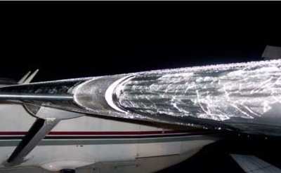
According to the board, a post-crash analysis of the actual weather conditions suggested the likelihood McGrath encountered severe icing related to super-cooled, large water droplets (photo of ice on the wing of a Cessna Caravan above). Further, despite fully-conforming to FAA standards, the weather briefing never warned the McGrath he might encounter such conditions.

The NTSB officially lists the probable cause of this accident as the pilot's in-flight loss of control following an inadvertent encounter with unforecast severe icing conditions. A factor in the accident was the inaccurate icing forecast developed by the NWS Aviation Weather Center.

FMI: www.ntsb.gov

Advertisement

More News

Unfortunate... ANN/SportPlane Resource Guide Adds To Cautionary Advisories

The Industry Continues to be Rocked By Some Questionable Operations Recent investigations and a great deal of data has resulted in ANN’s SportPlane Resource Guide’s rep>[...]

ANN FAQ: Turn On Post Notifications

Make Sure You NEVER Miss A New Story From Aero-News Network Do you ever feel like you never see posts from a certain person or page on Facebook or Instagram? Here’s how you c>[...]

ANN's Daily Aero-Term (04.29.24): Visual Approach Slope Indicator (VASI)

Visual Approach Slope Indicator (VASI) An airport lighting facility providing vertical visual approach slope guidance to aircraft during approach to landing by radiating a directio>[...]

ANN's Daily Aero-Term (04.28.24): Airport Marking Aids

Airport Marking Aids Markings used on runway and taxiway surfaces to identify a specific runway, a runway threshold, a centerline, a hold line, etc. A runway should be marked in ac>[...]

ANN's Daily Aero-Linx (04.28.24)

Aero Linx: The Skyhawk Association The Skyhawk Association is a non-profit organization founded by former Skyhawk Pilots which is open to anyone with an affinity for the A-4 Skyhaw>[...]

blog comments powered by Disqus


Advertisement

Advertisement

Podcasts

Advertisement

© 2007 - 2024 Web Development & Design by Pauli Systems, LC