Photographs Show Tracks Made My Astronauts, Rovers
NASA's Lunar Reconnaissance Orbiter (LRO) captured the sharpest
images ever taken from space of the Apollo 12, 14 and 17 landing
sites. Images show the twists and turns of the paths made when the
astronauts explored the lunar surface.
Apollo 17 Site NASA Image
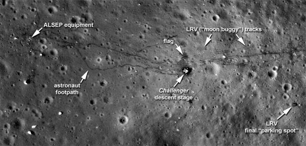
At the Apollo 17 site, the tracks laid down by the lunar rover
are clearly visible, along with the last foot trails left on the
moon. The images also show where the astronauts placed some of the
scientific instruments that provided the first insight into the
moon's environment and interior. "We can retrace the astronauts'
steps with greater clarity to see where they took lunar samples,"
said Noah Petro, a lunar geologist at NASA's Goddard Space Flight
Center in Greenbelt, Md., who is a member of the LRO project
science team.
All three images show distinct trails left in the moon's thin
soil when the astronauts exited the lunar modules and explored on
foot. In the Apollo 17 image, the foot trails, including the last
path made on the moon by humans, are easily distinguished from the
dual tracks left by the lunar rover, which remains parked east of
the lander. "The new low-altitude Narrow Angle Camera images
sharpen our view of the moon's surface," said Arizona State
University researcher Mark Robinson, principal investigator for the
Lunar Reconnaissance Orbiter Camera (LROC). "A great example is the
sharpness of the rover tracks at the Apollo 17 site. In previous
images the rover tracks were visible, but now they are sharp
parallel lines on the surface."
At each site, trails also run to the west of the landers, where
the astronauts placed the Apollo Lunar Surface Experiments Package
(ALSEP) to monitor the moon's environment and interior.
Apollo 12 Site NASA Image
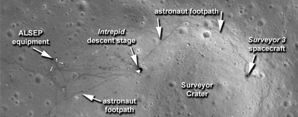
This equipment was a key part of every Apollo mission. It
provided the first insights into the moon's internal structure,
measurements of the lunar surface pressure and the composition of
its atmosphere. Apollo 11 carried a simpler version of the science
package. One of the details that shows up is a bright L-shape in
the Apollo 12 image. It marks the locations of cables running from
ALSEP's central station to two of its instruments. Although the
cables are much too small for direct viewing, they show up because
they reflect light very well.
The higher resolution of these images is possible because of
adjustments made to LRO's orbit, which is slightly oval-shaped or
elliptical. "Without changing the average altitude, we made the
orbit more elliptical, so the lowest part of the orbit is on the
sunlit side of the moon," said Goddard's John Keller, deputy LRO
project scientist. "This put LRO in a perfect position to take
these new pictures of the surface."
The maneuver lowered LRO from its usual altitude of
approximately 31 miles (50 kilometers) to an altitude that dipped
as low as nearly 13 miles (21 kilometers) as it passed over the
moon's surface. The spacecraft has remained in this orbit for 28
days, long enough for the moon to completely rotate. This allows
full coverage of the surface by LROC's Wide Angle Camera. The cycle
ended Wednesday when the spacecraft was returned to its 31-mile
orbit.
 Unfortunate... ANN/SportPlane Resource Guide Adds To Cautionary Advisories

