New Images Downplay Reports Of Recent Flows
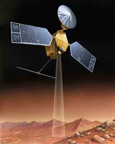
NASA tells ANN the agency's Mars Reconnaissance Orbiter is
examining several features on Mars that address the role of water
at different times in Martian history. Features examined with the
orbiter's advanced instruments include material deposited in two
gullies within the past eight years, polar ice layers formed in the
recent geologic past, and signs of water released by large impacts
when Mars was older.
As ANN reported last
December, discovery of the fresh gully deposits from
before-and-after images taken since 1999 by another orbiter, Mars
Global Surveyor, raised hopes that modern flows of liquid water had
been detected on Mars. Observations by the newer orbiter, which
reached Mars last year, suggest these deposits might instead have
resulted from landslides of loose, dry materials. Researchers
report this and other findings from Mars Reconnaissance Orbiter in
five papers in Friday's issue of the journal Science.
"The key question raised by these two deposits is whether water
is coming to the surface of Mars today," said Alfred McEwen of the
University of Arizona, Tucson, lead scientist for the spacecraft's
High Resolution Imaging Science Experiment camera and co-author of
three of the papers. "Our evidence suggests the new deposits did
not necessarily involve water."
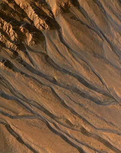
One of the fresh deposits is a stripe of relatively bright
material several hundred yards long that was not present in 1999
but appeared by 2004. The orbiter's Compact Reconnaissance Imaging
Spectrometer for Mars reveals the deposit is not frost, ice or a
mineral left behind by evaporation of salty water. Also, the
researchers inspected the slopes above this and five other
locations that have bright and apparently young deposits. The
slopes are steep enough for sand or loose, dry dust to flow down
the gullies. Bright material seen uphill could be the source.
Other gullies, however, offer strong evidence of liquid water
flowing on Mars within the last few million years, although perhaps
at a different phase of repeating climate cycles. Mars, like Earth,
has periodic changes in climate due to the cycles related to the
planets' tilts and orbits. Some eras during the cycles are warmer
than others. These gullies are on slopes too shallow for dry flows,
and images from Mars Reconnaissance Orbiter's high-resolution
camera show clear indicators of liquid flows, such as braided
channels and terraces within the gullies.
Another new finding from that camera may help undermine
arguments that very ancient Mars had a wet climate on a sustained
basis. Landscapes with branched channels and fan-like deposits
typical of liquid flows were found around several impact craters.
Images show close association between some of those flow features
and ponded deposits interpreted as material melted by the impact of
a meteoroid into ice-rich crust. This new evidence supports a
hypothesis that ancient water flows on the surface were episodic,
linked to impact events and subsurface heating, and not necessarily
the result of precipitation in a sustained warmer climate.
Crater-digging impacts were larger and more numerous during the
early Martian era when large drainage networks and other signs of
surface water were carved on many parts of the planet.
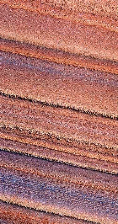
The Mars Reconnaissance Orbiter has examined ice-rich layered
deposits near the Martian poles with the ground-penetrating Shallow
Subsurface Radar instrument, and other experiments. The radar
detected layering patterns near the south pole that suggest
climatic periods of accumulating deposits have alternated with
periods of erosion, report Roberto Seu of the University of Rome
and his co-authors. Maria Zuber of the Massachusetts Institute of
Technology and her collaborators used effects of Mars' gravity on
the orbiter to check whether layered deposits at the south pole are
high-density material, such as rock, or lower-density such as ice.
Their observations add to other evidence that the layers are mostly
water.
Kenneth Herkenhoff of the US Geological Survey, Flagstaff, and
others used the high-resolution camera to trace a series of
distinctive layers near the north pole. An accompanying paper by
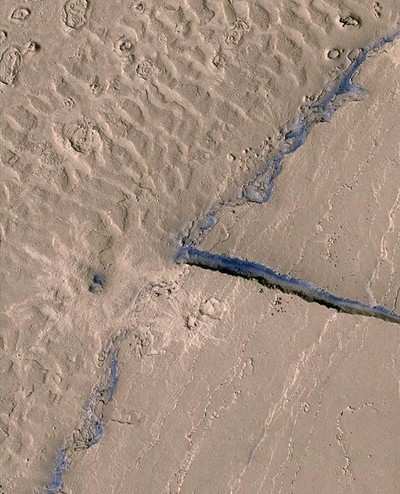
Windy Jaeger of the US Geological Survey, Flagstaff, and co-authors
uses images from the high-resolution camera to show lava flows
completely draping a young Martian channel network called Athabasca
Valles. This creates ponded lava over an expanse that other
researchers had interpreted in 2005 as a frozen sea.
"These latest increases in observational capabilities,
individually and in combination, reveal a more complex Mars, a
planet with a rich history that we are still learning to read,"
said Richard Zurek, project scientist for Mars Reconnaissance
Orbiter at NASA's Jet Propulsion Laboratory.
 Airborne 05.10.24: Icon Auction, Drunk MedEvac Pilot, Bell ALFA

