A WISE Move. NASA Delays Sky-Mapping Telescope Launch | Aero-News Network
Aero-News Network
RSS icon RSS feed
podcast icon MP3 podcast
Subscribe Aero-News e-mail Newsletter Subscribe

Airborne Unlimited -- Most Recent Daily Episodes

Episode Date

Airborne-Monday

Airborne-Tuesday

Airborne-Wednesday Airborne-Thursday

Airborne-Friday

Airborne On YouTube

Airborne-Unlimited-04.22.24

Airborne-Unlimited-04.16.24

Airborne-FlightTraining-04.17.24 Airborne-AffordableFlyers-04.18.24

Airborne-Unlimited-04.19.24

Join Us At 0900ET, Friday, 4/10, for the LIVE Morning Brief.
Watch It LIVE at
www.airborne-live.net

Fri, Dec 11, 2009

A WISE Move. NASA Delays Sky-Mapping Telescope Launch

Earliest Date For Launch Is Saturday, Weather Is A Question

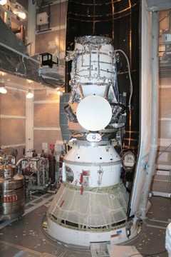
NASA has delayed the launch of its  Wide-field Infrared Survey Explorer, better known as WISE, due to a steering engine problem discovered Wednesday. The launch from Vandenberg Air Force Base has been re-scheduled for Saturday at the earliest, but there is only about a 20 percent chance of favorable weather for the launch.

The Associated Press reports that the original launch date was set for Friday. The problem was discovered while engineers completed final launch checks late in the day Wednesday.

WISE is an unmanned satellite carrying an infrared-sensitive telescope that will image the entire sky. Since objects around room temperature emit infrared radiation, the WISE telescope and detectors are kept very cold ... below -430°F /15 Kelvins, which is only 15° Centigrade above absolute zero ... by a cryostat, a box like an ice chest but filled with solid hydrogen instead of ice.

WISE will capture an image of the sky onto an infrared sensitive digital camera every 11 seconds. Each picture will cover an area of the sky 3 times larger than the full Moon. After 6 months WISE will have taken nearly 1,500,000 pictures covering the entire sky. Each picture will have one megapixel at each of four different wavelengths that range from 5 to 35 times longer than the longest waves the human eye can see. Data taken by WISE will be downloaded by radio transmission 4 times per day to computers on the ground which will combine the many images taken by WISE into an atlas covering the entire celestial sphere and a list of all the detected objects.

FMI: www.nasa.gov

Advertisement

More News

ANN's Daily Aero-Term (04.24.24): Runway Lead-in Light System

Runway Lead-in Light System Runway Lead-in Light System Consists of one or more series of flashing lights installed at or near ground level that provides positive visual guidance a>[...]

ANN's Daily Aero-Linx (04.24.24)

Aero Linx: Aviation Without Borders Aviation Without Borders uses its aviation expertise, contacts and partnerships to enable support for children and their families – at hom>[...]

Aero-FAQ: Dave Juwel's Aviation Marketing Stories -- ITBOA BNITBOB

Dave Juwel's Aviation Marketing Stories ITBOA BNITBOB ... what does that mean? It's not gibberish, it's a lengthy acronym for "In The Business Of Aviation ... But Not In The Busine>[...]

Classic Aero-TV: Best Seat in The House -- 'Inside' The AeroShell Aerobatic Team

From 2010 (YouTube Version): Yeah.... This IS A Really Cool Job When ANN's Nathan Cremisino took over the lead of our Aero-TV teams, he knew he was in for some extra work and a lot>[...]

Airborne Affordable Flyers 04.18.24: CarbonCub UL, Fisher, Affordable Flyer Expo

Also: Junkers A50 Heritage, Montaer Grows, Dynon-Advance Flight Systems, Vans' Latest Officially, the Carbon Cub UL and Rotax 916 iS is now in its 'market survey development phase'>[...]

blog comments powered by Disqus


Advertisement

Advertisement

Podcasts

Advertisement

© 2007 - 2024 Web Development & Design by Pauli Systems, LC