JPL Releases Photos Of Haiti Fault Lines | Aero-News Network
Aero-News Network
RSS icon RSS feed
podcast icon MP3 podcast
Subscribe Aero-News e-mail Newsletter Subscribe

Airborne Unlimited -- Most Recent Daily Episodes

Episode Date

Airborne-Monday

Airborne-Tuesday

Airborne-Wednesday Airborne-Thursday

Airborne-Friday

Airborne On YouTube

Airborne-Unlimited-04.22.24

Airborne-Unlimited-04.16.24

Airborne-FlightTraining-04.17.24 Airborne-AffordableFlyers-04.18.24

Airborne-Unlimited-04.19.24

Thu, Feb 04, 2010

JPL Releases Photos Of Haiti Fault Lines

Scientists Hope To Be Able To Measure Tectonic Plate Movements

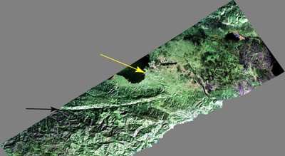
JPL's Uninhabited Aerial Vehicle Synthetic Aperture Radar (UAVSAR) captured this false-color composite image of the city of Port-au-Prince, Haiti, and the surrounding region on Jan. 27, 2010. Port-au-Prince is visible near the center of the image. The large dark line running east-west near the city is the main airport. UAVSAR left NASA's Dryden Flight Research Center in Edwards, CA, January 25, aboard a modified NASA Gulfstream III aircraft on a three-week campaign that will also take it to Central America.


Photo Courtesy JPL

Shortly before 1700 local time on January 12,a magnitude 7.0 earthquake struck southern Haiti. The earthquake's epicenter was about 25 kilometers (15 miles) west-southwest of Port-au-Prince, close to the west (left) edge of this image (yellow arrow). The large linear east-west valley in the mountains south of the city is the location of the major active fault zone responsible for the earthquake: the Enriquillo-Plantain Garden fault (black arrow). The fault extends from the western tip of Haiti past Port-au-Prince into the Dominican Republic to the east of this image. Historical records show that the southern part of Haiti was struck by a series of large earthquakes in the 1700s, and geologists believe those were also caused by ruptures on this fault zone.

Satellite interferometric synthetic aperture radar measurements show that the January 12 earthquake ruptured a segment of the fault extending from the epicenter westward over a length of about 40 kilometers (25 miles), leaving the section of the fault in this image unruptured. The earthquake has increased the stress on this eastern section of the fault south of Port-au-Prince and the section west of the rupture. This has significantly increased the risk of a future earthquake, according to a recent report by the U.S. Geological Survey.

This image will be combined with other images of the same area to be acquired later this month and in the future in order to measure the motion of Earth's surface during the time between images using a technique called interferometry.The interferometric measurements will allow scientists to study the pressures building up and being released on the fault at depth.

FMI: http://uavsar.jpl.nasa.gov/

Advertisement

More News

ANN's Daily Aero-Term (04.26.24): DETRESFA (Distress Phrase)

DETRESFA (Distress Phrase) The code word used to designate an emergency phase wherein there is reasonable certainty that an aircraft and its occupants are threatened by grave and i>[...]

ANN's Daily Aero-Linx (04.26.24)

Aero Linx: The International Association of Missionary Aviation (IAMA) The International Association of Missionary Aviation (IAMA) is comprised of Mission organizations, flight sch>[...]

Airborne 04.22.24: Rotor X Worsens, Airport Fees 4 FNB?, USMC Drone Pilot

Also: EP Systems' Battery, Boeing SAF, Repeat TBM 960 Order, Japan Coast Guard H225 Buy Despite nearly 100 complaints totaling millions of dollars of potential fraud, combined with>[...]

Airborne 04.24.24: INTEGRAL E, Elixir USA, M700 RVSM

Also: Viasat-uAvionix, UL94 Fuel Investigation, AF Materiel Command, NTSB Safety Alert Norges Luftsportforbund chose Aura Aero's little 2-seater in electric trim for their next gli>[...]

Airborne-NextGen 04.23.24: UAVOS UVH 170, magni650 Engine, World eVTOL Directory

Also: Moya Delivery Drone, USMC Drone Pilot, Inversion RAY Reentry Vehicle, RapidFlight UAVOS has recently achieved a significant milestone in public safety and emergency services >[...]

blog comments powered by Disqus


Advertisement

Advertisement

Podcasts

Advertisement

© 2007 - 2024 Web Development & Design by Pauli Systems, LC