Garmin G500H Receives EASA Certification In Eurocopter AS350 | Aero-News Network
Aero-News Network
RSS icon RSS feed
podcast icon MP3 podcast
Subscribe Aero-News e-mail Newsletter Subscribe

Airborne Unlimited -- Most Recent Daily Episodes

Episode Date

Airborne-Monday

Airborne-Tuesday

Airborne-Wednesday Airborne-Thursday

Airborne-Friday

Airborne On YouTube

Airborne-Unlimited-04.22.24

Airborne-Unlimited-04.16.24

Airborne-FlightTraining-04.17.24 Airborne-AffordableFlyers-04.18.24

Airborne-Unlimited-04.19.24

Wed, Mar 23, 2011

Garmin G500H Receives EASA Certification In Eurocopter AS350

European Garmin Dealer Kuerzi Avionics Completes STC And Begins G500H Installations

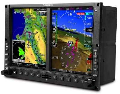
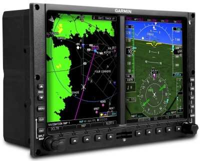
EASA has awarded certification to Garmin and European helicopter and aircraft services provider Kuerzi Avionics AG for the installation of the Garmin G500H glass cockpit in the Eurocopter AS350. With this STC, any authorized Garmin aviation dealer can install a G500H in an AS350 in accordance with EASA guidelines.

“Kuerzi Avionics is very proud to have worked with Garmin to achieve the first G500H EASA STC certification,” said Ralf Kuerzi, Managing Director of Kuerzi Avionics. “We have selected the G500H as we consider it to be the correct avionics solution to fulfil the requirements of our current and future customers.” “The G500H is becoming a very popular avionics suite with the helicopter community because of its vast capability and flexibility,” said Gary Kelley, Garmin’s vice president of marketing. “We are very pleased to work with Kuerzi on this STC and we believe the G500H is a great way to update AS350 helicopters so they can operate at a whole new level.”

The G500H is an all-glass avionics system designed specifically for the VFR Part 27 helicopter market. The primary flight display (PFD) shows attitude, airspeed, vertical speed, altitude and course/heading information, and the multi-function display (MFD) has detailed moving map graphics with the helicopter’s current position in relation to terrain, chart data, navaids, and flight plan routings. The system offers features like  helicopter synthetic vision technology (HSVT), XM WX Satellite Weather with NEXRAD, the ability to display video from a forward looking infrared (FLIR) camera or other video sources, and a helicopter-specific database with over 7,000 heliports and nearly 30,000 additional low altitude obstacles in addition to the already extensive obstacle database found in the fixed wing G500 system.

FMI: www.garmin.com

Advertisement

More News

ANN's Daily Aero-Term (04.26.24): DETRESFA (Distress Phrase)

DETRESFA (Distress Phrase) The code word used to designate an emergency phase wherein there is reasonable certainty that an aircraft and its occupants are threatened by grave and i>[...]

ANN's Daily Aero-Linx (04.26.24)

Aero Linx: The International Association of Missionary Aviation (IAMA) The International Association of Missionary Aviation (IAMA) is comprised of Mission organizations, flight sch>[...]

Airborne 04.22.24: Rotor X Worsens, Airport Fees 4 FNB?, USMC Drone Pilot

Also: EP Systems' Battery, Boeing SAF, Repeat TBM 960 Order, Japan Coast Guard H225 Buy Despite nearly 100 complaints totaling millions of dollars of potential fraud, combined with>[...]

Airborne 04.24.24: INTEGRAL E, Elixir USA, M700 RVSM

Also: Viasat-uAvionix, UL94 Fuel Investigation, AF Materiel Command, NTSB Safety Alert Norges Luftsportforbund chose Aura Aero's little 2-seater in electric trim for their next gli>[...]

Airborne-NextGen 04.23.24: UAVOS UVH 170, magni650 Engine, World eVTOL Directory

Also: Moya Delivery Drone, USMC Drone Pilot, Inversion RAY Reentry Vehicle, RapidFlight UAVOS has recently achieved a significant milestone in public safety and emergency services >[...]

blog comments powered by Disqus


Advertisement

Advertisement

Podcasts

Advertisement

© 2007 - 2024 Web Development & Design by Pauli Systems, LC