A WISE Move. NASA Delays Sky-Mapping Telescope Launch | Aero-News Network
Aero-News Network
RSS icon RSS feed
podcast icon MP3 podcast
Subscribe Aero-News e-mail Newsletter Subscribe

Airborne Unlimited -- Most Recent Daily Episodes

Episode Date

Airborne-Monday

Airborne-Tuesday

Airborne-Wednesday Airborne-Thursday

Airborne-Friday

Airborne On YouTube

Airborne-Unlimited-04.29.24

Airborne-Unlimited-04.23.24

Airborne-Unlimited-04.24.24 Airborne-FltTraining-04.25.24

Airborne-Unlimited-04.26.24

Fri, Dec 11, 2009

A WISE Move. NASA Delays Sky-Mapping Telescope Launch

Earliest Date For Launch Is Saturday, Weather Is A Question

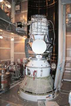
NASA has delayed the launch of its  Wide-field Infrared Survey Explorer, better known as WISE, due to a steering engine problem discovered Wednesday. The launch from Vandenberg Air Force Base has been re-scheduled for Saturday at the earliest, but there is only about a 20 percent chance of favorable weather for the launch.

The Associated Press reports that the original launch date was set for Friday. The problem was discovered while engineers completed final launch checks late in the day Wednesday.

WISE is an unmanned satellite carrying an infrared-sensitive telescope that will image the entire sky. Since objects around room temperature emit infrared radiation, the WISE telescope and detectors are kept very cold ... below -430°F /15 Kelvins, which is only 15° Centigrade above absolute zero ... by a cryostat, a box like an ice chest but filled with solid hydrogen instead of ice.

WISE will capture an image of the sky onto an infrared sensitive digital camera every 11 seconds. Each picture will cover an area of the sky 3 times larger than the full Moon. After 6 months WISE will have taken nearly 1,500,000 pictures covering the entire sky. Each picture will have one megapixel at each of four different wavelengths that range from 5 to 35 times longer than the longest waves the human eye can see. Data taken by WISE will be downloaded by radio transmission 4 times per day to computers on the ground which will combine the many images taken by WISE into an atlas covering the entire celestial sphere and a list of all the detected objects.

FMI: www.nasa.gov

Advertisement

More News

ANN's Daily Aero-Term (04.28.24): Airport Marking Aids

Airport Marking Aids Markings used on runway and taxiway surfaces to identify a specific runway, a runway threshold, a centerline, a hold line, etc. A runway should be marked in ac>[...]

Aero-News: Quote of the Day (04.28.24)

"It is extremely difficult, if not impossible, for manned aircraft to see a drone while conducting crop-enhancing and other aerial applications at low altitudes and high speeds. We>[...]

ANN's Daily Aero-Linx (04.28.24)

Aero Linx: The Skyhawk Association The Skyhawk Association is a non-profit organization founded by former Skyhawk Pilots which is open to anyone with an affinity for the A-4 Skyhaw>[...]

Aero-News: Quote of the Day (04.29.24)

“The T-54A benefits from an active Beechcraft King Air assembly line in Wichita, Kansas, where all required METS avionics and interior modifications are installed on the line>[...]

ANN's Daily Aero-Linx (04.29.24)

Aero Linx: Aerostar Owners Association The Association offers the Aerostar Owner a unique opportunity to tap an invaluable source of information concerning the care and feeding of >[...]

blog comments powered by Disqus


Advertisement

Advertisement

Podcasts

Advertisement

© 2007 - 2024 Web Development & Design by Pauli Systems, LC