Sun, Oct 13, 2013
Two Technologies Operating In Concert On A Single Aircraft
A new Diamond DA42 Geostar has successfully collected laser-scanning and photo-grammetry data during one single flight, according to a news release from Diamond Aircraft.
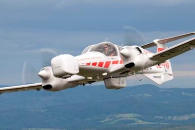
The team of Diamond Airborne Sensing succeeded in "perfect" sensor integration on the DA42 MPP. Both systems are integrated with sufficient resources for fuel and flight crew, meaning the Geostar is able to complete 10-hour survey flights with a range of up to 1,042 NM, equivalent to the flight route Vienna – Alicante. At an altitude of 10,000 feet it can even collect data from areas as large as 1,300 square miles, the size of the Spanish isle Majorca, during one single flight.
A photogrammetric camera, installed in a special pod on the aircraft’s nose, delivers accurate representations of the Earth's surface, so-called ortho-photos (aerial photos). A laser-scanner captures the terrain topography by firing a laser and measuring the time it takes for the laser to be reflected back from a point. The result of the collected measurements is a digital terrain model in the form of a point cloud. The scanner is mounted on the belly of the aircraft in a specifically designed pod. By merging the ortho-photo with the point cloud you get a precise, realistic 3D model of the object.
The special mission aircraft consists of state-of-the-art technology from renowned companies:
- Long-range airborne laser-scanner “LMS-Q780” from RIEGL Laser Measurement Systems
- High-format photogrammetric camera “Ultracam LP” from Microsoft/VEXCEL Imaging
- Gyro stabilization mount “SSM 350 L” von SOMAG for drastic movement reduction of the camera
- Flight management systems “CCNS 5 / AEROCONTROL 2” from IGI Systems for guidance, positioning and sensor management
Diamond says the Geostar is particularly suited for surveying cities, land areas, critical infrastructure (such as pipelines), glaciers or snow fields, but also for mapping damages caused through natural disasters.
(Image provided by Diamond)
More News
From 2023 (YouTube Version): Legacy of a Titan Robert (Bob) Anderson Hoover was a fighter pilot, test pilot, flight instructor, and air show superstar. More so, Bob Hoover was an i>[...]
Get The Latest in Aviation News NOW on Instagram Are you on Instagram yet? It's been around for a few years, quietly picking up traction mostly thanks to everybody's new obsession >[...]
Aero Linx: B-52H Stratofortress The B-52H Stratofortress is a long-range, heavy bomber that can perform a variety of missions. The bomber is capable of flying at high subsonic spee>[...]
Altimeter Setting The barometric pressure reading used to adjust a pressure altimeter for variations in existing atmospheric pressure or to the standard altimeter setting (29.92).>[...]
"Knowing that we play an active part in bettering people's lives is extremely rewarding. My team and I are very thankful for the opportunity to be here and to help in any way we ca>[...]
 Classic Aero-TV: Remembering Bob Hoover

