Precision Aerial Using UAS To Survey Drainage System In Texas | Aero-News Network
Aero-News Network
RSS icon RSS feed
podcast icon MP3 podcast
Subscribe Aero-News e-mail Newsletter Subscribe

Airborne Unlimited -- Most Recent Daily Episodes

Episode Date

Airborne-Monday

Airborne-Tuesday

Airborne-Wednesday Airborne-Thursday

Airborne-Friday

Airborne On YouTube

Airborne-Unlimited-05.06.24

Airborne-NextGen-04.30.24

Airborne-Unlimited-05.01.24 Airborne-AffordableFlyers--05.02.24

Airborne-Unlimited-05.03.24

Fri, Feb 02, 2018

Precision Aerial Using UAS To Survey Drainage System In Texas

Evaluating Conditions Following Hurricane Harvey

Precision Aerial Compliance Solutions, LLC (Precision Aerial), in partnership with The Woodlands Joint Powers Agency (WJPA) is providing drone LiDAR surveying for portions of The Woodlands drainage system in response to Hurricane Harvey. “The WJPA, on behalf of the Municipal Utility Districts it represents, is taking proactive steps now to help improve drainage during future rainstorms,” said James M. Stinson, PE, general manager for the WJPA.

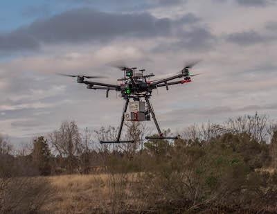
The WJPA is the central management agency for the ten Municipal Utility Districts (MUDs) that serve The Woodlands in Montgomery County. To evaluate current conditions along portions of Panther Creek and Spring Creek, Precision Aerial will utilize high-end, drone LiDAR to provide the laser assessment for the WJPA. Deploying one of the few drones in the country capable of this type of survey, this will be the first look of its kind at the drainage systems to evaluate current conditions and consider improvements for future preventive measures.

“This is the first use of drone LiDAR by a city or local governmental agency for a drainage survey in Texas and possibly in the whole country,” said Scott McGowan, President, Precision Aerial. “We are uniquely qualified to provide this type of service not only because of our experience, but we operate one of the few drones in the country capable of actually performing this type of scanning. Our cutting-edge LiDAR systems are setting a new industry standard for accuracy and efficiency, and it is something very special.”

Precision Aerial, a Conroe-based aerial data collection and inspection service company, is a member of the LJA Engineering family.

(Image provided with LJA Engineering news release)

FMI: www.lja.com

Advertisement

More News

ANN's Daily Aero-Term (05.02.24): Touchdown Zone Lighting

Touchdown Zone Lighting Two rows of transverse light bars located symmetrically about the runway centerline normally at 100 foot intervals. The basic system extends 3,000 feet alon>[...]

Aero-News: Quote of the Day (05.02.24)

“Discovery and innovation are central to our mission at Virgin Galactic. We’re excited to build on our successful record of facilitating scientific experiments in subor>[...]

Aero-News: Quote of the Day (05.03.24)

"We are reaching out to you today on behalf of the Popular Rotorcraft Association because we need your help. We are dangerously close to losing a critical resource that if lost, wi>[...]

ANN's Daily Aero-Term (05.03.24): UAS Traffic Management (UTM)

UAS Traffic Management (UTM) The unmanned aircraft traffic management ecosystem that will allow multiple low altitude BVLOS operations and which is separate from, but complementary>[...]

ANN's Daily Aero-Linx (05.03.24)

Aero Linx: Society of Aviation and Flight Educators (SAFE) SAFE is a member-oriented organization of aviation educators fostering professionalism and excellence in aviation through>[...]

blog comments powered by Disqus


Advertisement

Advertisement

Podcasts

Advertisement

© 2007 - 2024 Web Development & Design by Pauli Systems, LC