New Features Added Free, Download Available Soon
Subscribers to the "Pilot My-Cast" app on their iPhone, iPad, or
iTouch will soon be able to upgrade the service to include fuel
pricing and approach charts. Garmin subsidiary Digital Cyclone
announced the coming upgrade Monday.
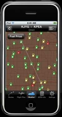
Showing Fuel Locations
The new features – fuel pricing and approach charts
– will be available soon at no additional cost from the
iTunes store. “We recognize that the essential information
pilots need, like weather, constantly changes. Pilot My-Cast is
designed to give personalized, up-to-the-minute information that is
relevant to a pilot’s specific flight,” said Craig
Burfeind, president of Digital Cyclone, Inc. “From getting
the best price on fuel to checking the weather to filing a flight
plan, Pilot My-Cast is all about putting information and tools in a
pilot’s hands that is tailored to them.”
Thanks to the real-time fuel price information, pilots will no
longer need to wonder where they can find the cheapest 100LL and
jet fuel. Pilot My-Cast displays fuel prices at the pilot’s
current airport and along their current route. The price
information is displayed in text as well as graphically on a map
where fuel pump icons are color-coded green, yellow and red based
on the price at that fuel pump. In addition, fuel pricing
information can be easily accessed via the AOPA Airport Directory
database that is also available on Pilot My-Cast.
The new approach chart feature makes it easy to access the
National Aeronautical Navigation Services Charts (AeroNav
Services), which was formerly NACO. These charts allow pilots to
quickly find and view all AeroNav Services Departure Procedures
(DP), Standard Terminal Arrival Routes (STARs), approach charts,
and airport diagrams. Pilot My-Cast is a premium weather, flight
planning and flight filing application exclusively for customers in
the U.S. and Canada. It is the first aviation weather and flight
planning app that visually displays the pilot’s planned route
of flight in conjunction with weather overlays. Pilots can
enter a route using airports, standard terminal arrival routes
(STARs), standard instrument departures (SIDs), and victor and jet
airways, and then see their flight path on a map with an overlay of
the weather. By combining the flight path with a weather overlay,
pilots can immediately see if their desired flight path is near
threatening weather. The real-time weather data overlays includes
radar, METARs, TAFs, lightning data, SIGMETS, AIRMETS, PIREPS,
NOTAMS, winds aloft, and more.
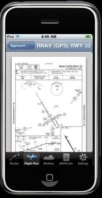
Showing Approach Chart
All weather and aviation data for Pilot My-Cast comes directly
from the foremost providers, such as the National Weather Service,
Environment Canada, and Federal Aviation Administration. Therefore,
customers can rest assured that they are receiving the up-to-the-
minute information that is imperative to all preflight
activities.
During EAA AirVenture Oshkosh, iPhone customers who have never
subscribed to Pilot My- Cast can try it for 30-days for free on
their iPhone. Throughout the rest of the year it is available in
the app store for a monthly fee of $9.99, or an annual subscription
of $99.99. To order Pilot My-
 ANN's Daily Aero-Term (04.25.24): Airport Rotating Beacon

