senseFly And IN-FLIGHT Data Join Forces For BVLOS Project In Calgary | Aero-News Network
Aero-News Network
RSS icon RSS feed
podcast icon MP3 podcast
Subscribe Aero-News e-mail Newsletter Subscribe

Airborne Unlimited -- Most Recent Daily Episodes

Episode Date

Airborne-Monday

Airborne-Tuesday

Airborne-Wednesday Airborne-Thursday

Airborne-Friday

Airborne On YouTube

Airborne-Unlimited-05.13.24

Airborne-NextGen-05.14.24

Airborne-Unlimited-05.15.24 Airborne-AffordableFlyers-05.16.24

Airborne-Unlimited-05.17.24

Tue, Oct 30, 2018

senseFly And IN-FLIGHT Data Join Forces For BVLOS Project In Calgary

First Such Testing To Be Done In A Major City In North America

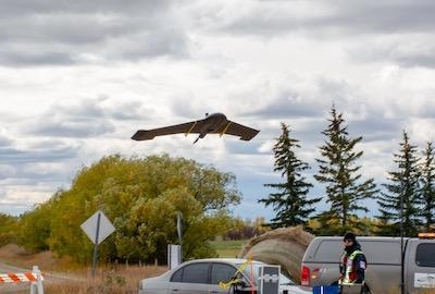
Canadian commercial drone operator IN-FLIGHT Data has, in collaboration with dronemaker senseFly, completed North America’s first urban BVLOS UAS (drone) project in a major city.

The project, carried out in the city of Calgary, Alberta, was commissioned to collect mapping data to support the development of a new graveyard site, the city’s first new cemetery since 1940. The mapping of the area, completed using a senseFly eBee Plus fixed-wing drone, saw IN-FLIGHT Data’s team conduct a total of 257 miles BVLOS operations at an average distance of 1.46 miles from the pilot, and began as part of IN-FLIGHT Data’s wider BVLOS UAS operations trial earlier this year. The aim of the trial was to demonstrate the safety and effectiveness of BVLOS UAS flights and the cost and efficiency benefits they can provide to citizens and governments alike.

“As the first new municipal graveyard built in Calgary in over 75 years, this is a landmark development for the city,” said Chris Healy, owner of IN-FLIGHT Data. “The trial we completed earlier this year, which was Canada’s largest BVLOS UAS operations trial to date, demonstrated that this technique can provide highly geo-accurate aerial data in a variety of different applications. This project was no exception and, importantly, flying beyond line of site ensured that all of our take-off and landing areas were respectfully located outside of the graveyard.”

Restricted ground access to the site meant that remotely launched drone operations were the obvious option. Since the site was situated near a protected nature reserve and bird sanctuary, drone use also minimized the project’s environmental impact, negating the need to drive vehicles onto the site and disturb wildlife.

Completed on Sept. 29, 2018, the data collected during the project was delivered to the City of Calgary and will support construction management as the development of the graveyard commences. In addition to providing valuable inventory data, enabling city officials to identify the real estate available at the site, the findings will also be shared with the citizens of Calgary to follow the progress of the site construction.

“The success of this project indicates that the potential for BVLOS operations in urban, city environments is huge,” said Healy. “When correctly planned and executed, including ongoing communication with local air traffic control, and live air traffic monitoring within the drone’s flight software, BVLOS operations are an incredibly efficient, safe and cost-effective tool for mapping cities. With fewer personnel and operational requirements, BVLOS drone flights are key in facilitating and reducing the costs of urban UAS operations, and we’re excited to see what the future holds for BVLOS in other urban applications.”

(Image provided with senseFly news release)

FMI: www.sensefly.com

Advertisement

More News

Classic Aero-TV: Remembering Bob Hoover

From 2023 (YouTube Version): Legacy of a Titan Robert (Bob) Anderson Hoover was a fighter pilot, test pilot, flight instructor, and air show superstar. More so, Bob Hoover was an i>[...]

ANN FAQ: Follow Us On Instagram!

Get The Latest in Aviation News NOW on Instagram Are you on Instagram yet? It's been around for a few years, quietly picking up traction mostly thanks to everybody's new obsession >[...]

ANN's Daily Aero-Linx (05.15.24)

Aero Linx: B-52H Stratofortress The B-52H Stratofortress is a long-range, heavy bomber that can perform a variety of missions. The bomber is capable of flying at high subsonic spee>[...]

ANN's Daily Aero-Term (05.15.24):Altimeter Setting

Altimeter Setting The barometric pressure reading used to adjust a pressure altimeter for variations in existing atmospheric pressure or to the standard altimeter setting (29.92).>[...]

Aero-News: Quote of the Day (05.16.24)

"Knowing that we play an active part in bettering people's lives is extremely rewarding. My team and I are very thankful for the opportunity to be here and to help in any way we ca>[...]

blog comments powered by Disqus


Advertisement

Advertisement

Podcasts

Advertisement

© 2007 - 2024 Web Development & Design by Pauli Systems, LC