Thu, Aug 16, 2018
High Resolution Satellite Imagery Used To Speed Claims Processing
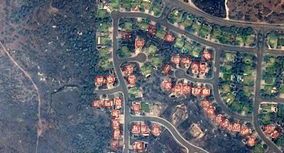
Powered by Airbus Aerial’s data analytics and high-resolution satellite imagery from Airbus Intelligence, insurance companies are helping their policyholders begin to recover from the tragic Carr wildfires — already one of the top ten most destructive wildfires in California history. At present, these wildfires continue to burn and are only 27% contained.
Thanks to Aerial’s cloud platform, insurance damage triage tool kit, and suite of analytics, blended with satellite imagery of targeted areas from Airbus Intelligence, insurance companies can usually process a claim and inform their customers before the customer even knows a loss has occurred.
It is critical for insurers to quickly understand the impacts to their insured assets and policyholders to help their customers restore their lives as soon as possible. Airbus Aerial’s services help enable insurance companies to process and pay claims remotely – even as fires continue to burn – better enabling policyholders to secure long-term housing and restore their lives quickly. Using before/after aerial imagery of an affected area also helps insurance companies reduce costs associated with assessing claims.
Aerial directly tasks Airbus high-resolution satellites to capture data exactly around the locations of greatest interest to our customers. Within hours, this data is processed in Aerial’s cloud-based data platform. Next, Aerial’s proprietary machine-learning algorithms take this data and highlight the properties that are completely destroyed and a total loss.
These wildfires offer a prime example of the benefit of multiple aerial data sources. In this case, drones and manned aircraft cannot be used to make way for first responders, or for damage assessments by insurance companies because of poor visibility due to smoke and ash, as well as airspace flying restrictions.
Aerial has delivered these types of essential services to major insurance companies in times of disaster before. In 2017 during Hurricanes Harvey and Irma, which caused between $150 billion and $200 billion in damage to Texas and Florida, Aerial provided analytics and imagery from drones, manned and unmanned aircraft and from satellites to help insurance companies settle claims quickly and efficiently.
(Image provided with Airbus Aerial news release)
More News
Aero Linx: Model Aeronautical Association of Australia MAAA clubs are about fun flying, camaraderie and community. For over 75 years, the MAAA has been Australia’s largest fl>[...]
Touchdown Zone Lighting Two rows of transverse light bars located symmetrically about the runway centerline normally at 100 foot intervals. The basic system extends 3,000 feet alon>[...]
“Discovery and innovation are central to our mission at Virgin Galactic. We’re excited to build on our successful record of facilitating scientific experiments in subor>[...]
How To Get A Story On Aero-TV News/Feature Programming How do I submit a story idea or lead to Aero-TV? If you would like to submit a story idea or lead, please contact Jim Campbel>[...]
Student Pilot Reported That During Rotation, “All Of A Sudden The Back Of The Plane Kicked To The Right..." Analysis: The student pilot reported that during rotation, “>[...]
 ANN's Daily Aero-Linx (05.02.24)

