DJI Geofences Much Of Iraq And Syria | Aero-News Network
Aero-News Network
RSS icon RSS feed
podcast icon MP3 podcast
Subscribe Aero-News e-mail Newsletter Subscribe

Airborne Unlimited -- Most Recent Daily Episodes

Episode Date

Airborne-Monday

Airborne-Tuesday

Airborne-Wednesday Airborne-Thursday

Airborne-Friday

Airborne On YouTube

Airborne-Unlimited-04.29.24

Airborne-NextGen-04.30.24

Airborne-Unlimited-05.01.24 Airborne-AffordableFlyers--05.02.24

Airborne-Unlimited-05.03.24

Mon, May 01, 2017

DJI Geofences Much Of Iraq And Syria

Goal Is To Prevent ISIS From Using Its Drones

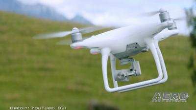
Following reports of ISIS weaponizing small UAVs, DJI has reportedly taken steps to keep the radical Islamic group from using its aircraft.

Vice News reports that DJI has geofenced much of Syria and Iraq. The internal software in the aircraft now recognizes much of those two countries as "no fly zones" much like airspace around an airport or military installation.

Last fall, DJI has issued a statement saying it was prepared to "provide whatever technical assistance we can" to help prevent the use of its aircraft as instruments of war. 

DJI Spokeswoman Dr. Barbara Stelzner said in an email to Vice News that the company's geofencing system is "designed to advise pilots of airspace restrictions, and was never intended to enforce laws or thwart people who want to misuse our products.” She did not way whether the company was specifically asked to geofence much of Iraq and Syria.

DJI has a page on its website where operators can search for geofenced areas worldwide, though Iraq and Syria are not yet on the list.

“Certain areas vital for aviation safety or national security are marked as restricted in our geofencing system, and we are constantly adjusting those areas to account for temporary conditions that create special restrictions, such as wildfires and major public events,” Stelzner said in the email.

(Image from file)

FMI: Original Report 

Advertisement

More News

ANN's Daily Aero-Term (05.02.24): Touchdown Zone Lighting

Touchdown Zone Lighting Two rows of transverse light bars located symmetrically about the runway centerline normally at 100 foot intervals. The basic system extends 3,000 feet alon>[...]

Aero-News: Quote of the Day (05.02.24)

“Discovery and innovation are central to our mission at Virgin Galactic. We’re excited to build on our successful record of facilitating scientific experiments in subor>[...]

Aero-News: Quote of the Day (05.03.24)

"We are reaching out to you today on behalf of the Popular Rotorcraft Association because we need your help. We are dangerously close to losing a critical resource that if lost, wi>[...]

ANN's Daily Aero-Term (05.03.24): UAS Traffic Management (UTM)

UAS Traffic Management (UTM) The unmanned aircraft traffic management ecosystem that will allow multiple low altitude BVLOS operations and which is separate from, but complementary>[...]

ANN's Daily Aero-Linx (05.03.24)

Aero Linx: Society of Aviation and Flight Educators (SAFE) SAFE is a member-oriented organization of aviation educators fostering professionalism and excellence in aviation through>[...]

blog comments powered by Disqus


Advertisement

Advertisement

Podcasts

Advertisement

© 2007 - 2024 Web Development & Design by Pauli Systems, LC