World’s First Integrated Multispectral Imaging Drone Built To Power Farming’s Next Generation
DJI says it is setting a new standard for easy-to-use agricultural drone applications with P4 Multispectral, the world’s first fully integrated multispectral imaging drone designed for precision agriculture and environmental management.
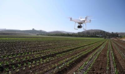
P4 Multispectral combines data from six separate sensors to measure the health of crops, from individual plants to entire fields, as well as weeds, insects and a variety of soil conditions. With the agriculture drone market expected to grow from $1.2 billion USD in 2019 to $4.8 billion by 2024, P4 Multispectral provides farmers and agronomists with a new tool to improve crop yields, cut costs and helps environmental professionals easily monitor vegetation on the land they manage.
“P4 Multispectral has the promise to transform the agriculture and land management industries by collecting precise plant-level data without having to send personnel into the field for manual surveys,” said Jan Gasparic, Director of Strategic Partnerships at DJI. “By combining multispectral imaging into a trusted, efficient and affordable tool, DJI is making this transformative technology more accessible to professionals around the world who are pioneering the adoption of drones in their industries.”
P4 Multispectral features a gimbal-stabilized imaging system composed of one RGB camera and a multispectral camera array with five narrow band sensors - including red edge and near infrared - that are capable of capturing visible and invisible light. This data gives trained professionals unique insights into vegetation stress, soil composition as well as water salinity and contamination. An additional integrated spectral sunlight sensor maximizes the accuracy and consistency of data collection during missions flown at different times of day.
Seamless integration into the DJI Ground Station Pro flight planning app allows pilots to switch between real-time views of the drone’s RGB video camera and Normalized Difference Vegetation Index (NDVI) output for immediate insights while in the field. An integrated RTK positioning module and TimeSync system support real-time, accurate positioning data for each image, optimizing photogrammetric results and providing centimeter-level accurate measurements.
P4 Multispectral is compatible with standard industry workflows including flight programming, mapping, and analytics software from DJI and other leading providers. Using the DJI GS Pro application, users can create automated and repeatable missions including flight planning, mission execution, and flight data management. Data collected can be easily imported into DJI Terra or a suite of third-party software including Pix4D Mapper and DroneDeploy, for analysis and to generate additional vegetation index maps. In addition, P4 Multispectral users can enhance the accuracy of RTK positioning without an internet connection by using DJI’s D-RTK 2 High-Precision GNSS Mobile Station, which supports all major global satellite navigation systems, or using a third-party network RTK via an iPad with an internet connection.
Built on the iconic Phantom airframe, P4 Multispectral leverages DJI’s powerful OcuSync transmission system for a smooth flight experience with less signal interference, enhanced video transmission, and a 7km (4.3 mile) maximum transmission range. Each of its 2-megapixel cameras feature a global shutter for precise imaging during flight with a maximum 27 minutes of flight time per battery.
DJI P4 Multispectral will be available in October through authorized DJI Enterprise dealers worldwide. The P4 Multispectral costs $6,499 (USD) and comes with a 1-year free license to DJI Terra (Basic) Windows software and a 1-year free license to DJI GS Pro (Team-Professional) iPad app. Customers can also purchase the P4 Multispectral with the D-RTK 2 Mobile Base Station for a total of $9,100. All purchases of a P4 Multispectral in the United States, Canada, China, Australia, Japan, United Kingdom and the European Union will enjoy a 1-year Enterprise Shield Basic coverage on their new drone, at no additional cost.
P4 Multispectral was announced at AirWorks 2019, DJI’s annual commercial drone conference that brings together DJI customers and its ecosystem of drone solution providers for three days to inspire, connect and energize attendees about the beneficial drone applications available to enterprises today as well as the future of the global commercial drone industry. As part of the introduction of P4 Multispectral, DJI was joined on-stage by DroneDeploy’s CEO, Mike Winn and Corteva Agriscience’s U.S. Digital Ag Lead, Jeremy Groeteke to share their insights on drone technology in agriculture.
(Image provided with DJI news release)
 ANN's Daily Aero-Term (05.05.24): Omnidirectional Approach Lighting System

