Tue, Jan 26, 2010
Parent Company Mundus Group Signs LOI With Litigation Animation
Inc.
 One of the recognized roles for non-military UAVs is as a
camera platform that can go places a conventional aircraft can't.
Mundus Group has signed a Letter of Intent with Litigaion Animation
Inc. to provide that company with forensic images for animation
used in litigation. The camera platform will be UAVs manufactured
by it's subsidiary, AirStar.
One of the recognized roles for non-military UAVs is as a
camera platform that can go places a conventional aircraft can't.
Mundus Group has signed a Letter of Intent with Litigaion Animation
Inc. to provide that company with forensic images for animation
used in litigation. The camera platform will be UAVs manufactured
by it's subsidiary, AirStar.
Aerial images are used to help orientate the viewer to an
accident scene. They can also be used to determine lines of sight,
distances, positions and establish time lines for various events.
LAI uses helicopters, airplanes, satellites, cranes, remote control
aircraft, and pole cams to acquire aerial images. Survey data is
used to modify aerials to correct dimensions.
Litigation Animations says the advantages of having a strategic
relationship with AirStar include the cost effectiveness of quick
access and professional aerial photography at a fraction of the
cost of using the full sized manned helicopters. Manned helicopters
are not able to fly in close proximity to the site like the UAVs,
which are smoother, quieter and generally unnoticed, as they do not
disturb the immediate vicinity as a manned helicopter would. With
the public safety benefits and superior aerial maneuverability of
AirStar's UAVs, they are also used to videotape vehicle motion
during accident reconstruction. The subsequent video is then used
to calibrate the vehicle velocities.
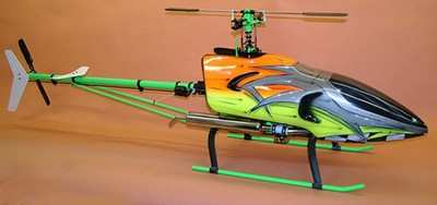
File Photo
LAI engineers 3D mathematical computer models that are driven by
the experts' simulation data, 3D survey data, eyewitness testimony,
and physical evidence gathered from the scene. These accurate 3D
computer models are used to determine lines of sight, and objects'
positions and size.
Accident photographs are engineered into three-dimensional
models using computer photogrammetry. The three-dimensional scene
can now be measured. Computer cameras can also be placed anywhere
in the scene to view lines of sight and obstructions. Accident
video is also engineered into a three-dimensional scene where
velocity and acceleration can now be calculated.
More News
DETRESFA (Distress Phrase) The code word used to designate an emergency phase wherein there is reasonable certainty that an aircraft and its occupants are threatened by grave and i>[...]
"General aviation is at the forefront of developing and introducing innovative technologies that will transform the entire aviation industry..." Source: Kyle Martin, Vice President>[...]
Direct Straight line flight between two navigational aids, fixes, points, or any combination thereof. When used by pilots in describing off-airway routes, points defining direct ro>[...]
Aero Linx: Women in Corporate Aviation Women in Corporate Aviation support individuals seeking career advancement and professional development in the business aviation industry. Me>[...]
“We would like to thank the many volunteers that help throughout the year to pull off the event, as well as the several reviewers, judges, and SURVICE staff that provide team>[...]
 ANN's Daily Aero-Term (04.26.24): DETRESFA (Distress Phrase)

