Trimble Partners With Multirotor Unmanned Aircraft System Manufacturer | Aero-News Network
Aero-News Network
RSS icon RSS feed
podcast icon MP3 podcast
Subscribe Aero-News e-mail Newsletter Subscribe

Airborne Unlimited -- Most Recent Daily Episodes

Episode Date

Airborne-Monday

Airborne-Tuesday

Airborne-Wednesday Airborne-Thursday

Airborne-Friday

Airborne On YouTube

Airborne-Unlimited-04.22.24

Airborne-Unlimited-04.16.24

Airborne-FlightTraining-04.17.24 Airborne-AffordableFlyers-04.18.24

Airborne-Unlimited-04.19.24

Join Us At 0900ET, Friday, 4/10, for the LIVE Morning Brief.
Watch It LIVE at
www.airborne-live.net

Wed, May 06, 2015

Trimble Partners With Multirotor Unmanned Aircraft System Manufacturer

New Geospatial And Agriculture Workflows And Deliverables Through Additional Aerial Imaging Solutions

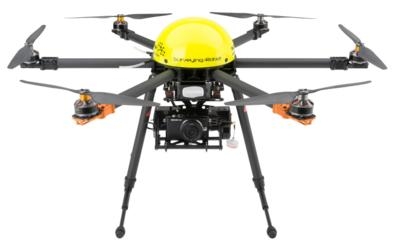
Trimble has partnered with leading unmanned aircraft system (UAS) manufacturer Multirotor service-drone, GmbH. The collaboration will allow Trimble to expand its existing UAS portfolio to provide its customers with additional solutions to choose from based on their aerial imaging project needs.

The announcement was made at the AUVSI's Unmanned Systems 2015 Conference and Exhibition, the largest international event in the unmanned systems and robotics market.

Multirotor service-drone, based in Germany, is a leading manufacturer of multirotor systems known for innovation and technology leadership. Trimble will be Multirotor service-drone's exclusive provider of multirotor vehicles for aerial mapping use in surveying, construction, mining, agriculture, oil and gas, and utilities. The combination of Multirotor service-drone's stable and reliable platforms with Trimble's industry-leading sensor technology and workflow efficiencies will provide customers with best-in-class solutions for aerial data capture. 

Unmanned multirotor systems are powerful solutions for visually documenting smaller areas, vertical structures or environments where holding position is important. High-resolution imagery, orthophotos, terrain models and normalized difference vegetation index (NDVI) map deliverables created from multirotor data provide valuable information for the survey, engineering and agriculture industries that Trimble serves.

"We are very excited to partner with Multirotor service-drone. At Trimble we're always looking for ways to meet our customer's needs and enable them to solve the complex problems they encounter every day," said Todd Steiner, product marketing director in Trimble's Geospatial Division. "The collaboration will enable our customers to use a technology rapidly growing in popularity due to its flexibility and productivity."

(Image provided by Multirotor)

FMI: www.service-drone.com/en, www.trimble.com

Advertisement

More News

ANN's Daily Aero-Term (04.25.24): Airport Rotating Beacon

Airport Rotating Beacon A visual NAVAID operated at many airports. At civil airports, alternating white and green flashes indicate the location of the airport. At military airports>[...]

ANN's Daily Aero-Linx (04.25.24)

Aero Linx: Fly for the Culture Fly For the Culture, Inc. is a 501(c)(3) non-profit organization that serves young people interested in pursuing professions in the aviation industry>[...]

Klyde Morris (04.22.24)

Klyde Is Having Some Issues Comprehending The Fed's Priorities FMI: www.klydemorris.com>[...]

Airborne 04.24.24: INTEGRAL E, Elixir USA, M700 RVSM

Also: Viasat-uAvionix, UL94 Fuel Investigation, AF Materiel Command, NTSB Safety Alert Norges Luftsportforbund chose Aura Aero's little 2-seater in electric trim for their next gli>[...]

Airborne 04.22.24: Rotor X Worsens, Airport Fees 4 FNB?, USMC Drone Pilot

Also: EP Systems' Battery, Boeing SAF, Repeat TBM 960 Order, Japan Coast Guard H225 Buy Despite nearly 100 complaints totaling millions of dollars of potential fraud, combined with>[...]

blog comments powered by Disqus


Advertisement

Advertisement

Podcasts

Advertisement

© 2007 - 2024 Web Development & Design by Pauli Systems, LC