PC Aviator Launches MegaSceneryEarth For FSX | Aero-News Network
Aero-News Network
RSS icon RSS feed
podcast icon MP3 podcast
Subscribe Aero-News e-mail Newsletter Subscribe

Airborne Unlimited -- Most Recent Daily Episodes

Episode Date

Airborne-Monday

Airborne-Tuesday

Airborne-Wednesday Airborne-Thursday

Airborne-Friday

Airborne On YouTube

Airborne-Unlimited-04.22.24

Airborne-Unlimited-04.16.24

Airborne-FlightTraining-04.17.24 Airborne-AffordableFlyers-04.18.24

Airborne-Unlimited-04.19.24

Join Us At 0900ET, Friday, 4/10, for the LIVE Morning Brief.
Watch It LIVE at
www.airborne-live.net

Sat, Dec 27, 2008

PC Aviator Launches MegaSceneryEarth For FSX

Hyper-Realistic Photo-Scenery On-Demand

MegaScenery publisher PC Aviator, in partnership with MegaScenery developer Aerosoft Australia Pty Ltd, announced Friday the launch of the next evolutionary phase of the MegaScenery brand -- MegaSceneryEarth.

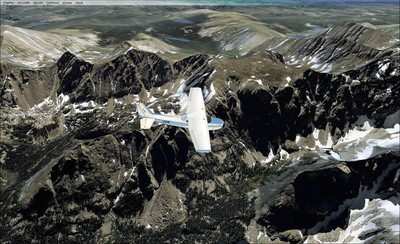
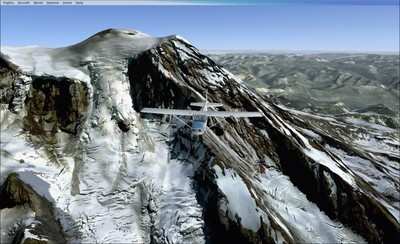
MegaSceneryEarth is a product line that involves the massive project of mapping as much of the earth as possible as ready-to-use photoscenery (created from aerial photography) for Microsoft Flight Simulator X. The focus initially will be on the continental USA.

End users visit the MegaSceneryEarth website, choose the pre-created areas of photoscenery packaged as tiles varying between 1200 and 2800 square miles and download them instantly after purchase.

While the concept of downloaded software is certainly not new, the concept of a megastore of on-demand, ready-to-use photoscenery for Microsoft Flight Simulator available for instant download is as a result of the MegaSceneryEarth model.

Aerial photographs for the MegaSceneryEarth product line are from source data of primarily 1 and (some) 2 meters per pixel resolution and are displayed in Microsoft Flight Simulator at 1.19 meters per pixel. The end result for the user is a very realistic representation of the particular area being flown in Flight Simulator.

As well as for entertainment, MegaScenery notes the product line also has sorts of positive implications for licensed and trainee pilots wanting to become familiar with visual flight operations in particular geographical areas.

This project was made possible as a result of the ever increasing speed of internet connection bandwidth for consumers however users who do not have fast connections the website also offers opportunities to have DVD recreations mailed on demand in lieu of downloading.

The pricing for the scenery tiles is as little as $3.00 per area when consumers take up maximum volume discounts.

FMI: www.megasceneryearth.com, www.pcaviator.com, www.aerosoft.com.au

Advertisement

More News

ANN's Daily Aero-Term (04.24.24): Runway Lead-in Light System

Runway Lead-in Light System Runway Lead-in Light System Consists of one or more series of flashing lights installed at or near ground level that provides positive visual guidance a>[...]

ANN's Daily Aero-Linx (04.24.24)

Aero Linx: Aviation Without Borders Aviation Without Borders uses its aviation expertise, contacts and partnerships to enable support for children and their families – at hom>[...]

Aero-FAQ: Dave Juwel's Aviation Marketing Stories -- ITBOA BNITBOB

Dave Juwel's Aviation Marketing Stories ITBOA BNITBOB ... what does that mean? It's not gibberish, it's a lengthy acronym for "In The Business Of Aviation ... But Not In The Busine>[...]

Classic Aero-TV: Best Seat in The House -- 'Inside' The AeroShell Aerobatic Team

From 2010 (YouTube Version): Yeah.... This IS A Really Cool Job When ANN's Nathan Cremisino took over the lead of our Aero-TV teams, he knew he was in for some extra work and a lot>[...]

Airborne Affordable Flyers 04.18.24: CarbonCub UL, Fisher, Affordable Flyer Expo

Also: Junkers A50 Heritage, Montaer Grows, Dynon-Advance Flight Systems, Vans' Latest Officially, the Carbon Cub UL and Rotax 916 iS is now in its 'market survey development phase'>[...]

blog comments powered by Disqus


Advertisement

Advertisement

Podcasts

Advertisement

© 2007 - 2024 Web Development & Design by Pauli Systems, LC