Navy UAV Down In MD | Aero-News Network
Aero-News Network
RSS icon RSS feed
podcast icon MP3 podcast
Subscribe Aero-News e-mail Newsletter Subscribe

Airborne Unlimited -- Most Recent Daily Episodes

Episode Date

Airborne-Monday

Airborne-Tuesday

Airborne-Wednesday Airborne-Thursday

Airborne-Friday

Airborne On YouTube

Airborne-Unlimited-04.22.24

Airborne-Unlimited-04.16.24

Airborne-FlightTraining-04.17.24 Airborne-AffordableFlyers-04.18.24

Airborne-Unlimited-04.19.24

Tue, Jun 12, 2012

Navy UAV Down In MD

Officials Say Aircraft Was Conducting A Routine Maintenance Flight

A Navy UAV has gone down on the Eastern Shore of Maryland, according to the Navy and the Coast Guard.

Initial reports are that the 44-foot UAV is part of the Navy's Patuxent River Naval Station's Unmanned Aviation and Strike Weapons program. The Associated Press reports that it went down just after noon Monday near Bloodsworth Island. No injuries were reported in connection with the accident.

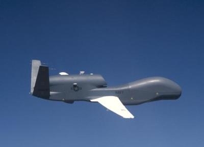
The blog SeaWaves indicates that the UAV is one of five Global Hawk aircraft that was acquired from the Air Force for the Broad Area Maritime Surveillance Demonstrator program. The BAMS-D program has been working on employing high-altitude unmanned patrol aircraft since November, 2006.

According to the NAVAIR website, The Navy’s RQ-4A Global Hawk UAVs fly up to 60,000 feet. The high-flying aerial vehicle can operate for more than 30 hours above most weather. Imagery and other data obtained by the aircraft feeds by satellite into the Navy ground segment consisting of a mission control element, a launch and recovery element, and a Navy-designed Tactical Auxiliary Ground Station (TAGS). Flown by Navy and Navy contractor pilots, the asset is controlled from Naval Air Station (NAS) Patuxent River, MD.

BAMS-D was used to develop methods for integrating the Automatic Identification System (AIS) into Fleet operations. Experimentation using BAMS-D also benefited the Naval Sea Systems Command Ocean Surveillance Initiative and Oceanographer of the Navy office activities assessing usefulness of long-endurance, high-altitude unmanned systems in collecting Fleet-relevant meteorological data.

The Coast Guard has set up a safety zone around the marshy area where the aircraft went down in Dorchester County, MD, according to USCG Petty Officer Jonathan Lindberg. (File photo of Navy Global Hawk)

FMI: www.navy.mil, www.uscg.mil

Advertisement

More News

ANN's Daily Aero-Term (04.26.24): DETRESFA (Distress Phrase)

DETRESFA (Distress Phrase) The code word used to designate an emergency phase wherein there is reasonable certainty that an aircraft and its occupants are threatened by grave and i>[...]

ANN's Daily Aero-Linx (04.26.24)

Aero Linx: The International Association of Missionary Aviation (IAMA) The International Association of Missionary Aviation (IAMA) is comprised of Mission organizations, flight sch>[...]

Airborne 04.22.24: Rotor X Worsens, Airport Fees 4 FNB?, USMC Drone Pilot

Also: EP Systems' Battery, Boeing SAF, Repeat TBM 960 Order, Japan Coast Guard H225 Buy Despite nearly 100 complaints totaling millions of dollars of potential fraud, combined with>[...]

Airborne 04.24.24: INTEGRAL E, Elixir USA, M700 RVSM

Also: Viasat-uAvionix, UL94 Fuel Investigation, AF Materiel Command, NTSB Safety Alert Norges Luftsportforbund chose Aura Aero's little 2-seater in electric trim for their next gli>[...]

Airborne-NextGen 04.23.24: UAVOS UVH 170, magni650 Engine, World eVTOL Directory

Also: Moya Delivery Drone, USMC Drone Pilot, Inversion RAY Reentry Vehicle, RapidFlight UAVOS has recently achieved a significant milestone in public safety and emergency services >[...]

blog comments powered by Disqus


Advertisement

Advertisement

Podcasts

Advertisement

© 2007 - 2024 Web Development & Design by Pauli Systems, LC