NYC VFR Chart Updated For Helicopters | Aero-News Network
Aero-News Network
RSS icon RSS feed
podcast icon MP3 podcast
Subscribe Aero-News e-mail Newsletter Subscribe

Airborne Unlimited -- Most Recent Daily Episodes

Episode Date

Airborne-Monday

Airborne-Tuesday

Airborne-Wednesday Airborne-Thursday

Airborne-Friday

Airborne On YouTube

Airborne-Unlimited-04.29.24

Airborne-Unlimited-04.23.24

Airborne-Unlimited-04.24.24 Airborne-FltTraining-04.25.24

Airborne-Unlimited-04.26.24

Sat, Oct 07, 2006

NYC VFR Chart Updated For Helicopters

New Chart Makes It Easier To Navigate Big Apple

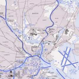
The Eastern Region Helicopter Council (ERHC) had a special surprise during its annual meeting held the last weekend of September in Hanover, NJ. To the delight of its members, the ERHC distributed copies of the newest New York City VFR Helicopter Route Chart, hot off the presses from the National Aeronautical Charting Office. 

The DRHC had worked for over a year with the FAA charting office to ensure the new charts were updated and improved before being reissued. 

The sixth edition of the chart has some major helpful changes. The main body of the chart has been expanded west, north and east to include three additional airports with routes connecting them to the main route structure.  The downtown and Statue of Liberty-Ellis Island inset charts were combined into one inset chart to make room for a brand new Long Island inset chart, which depicts a newly revised South Shore Route, which extends eastward and offshore from the metro area to Montauk.

The new chart became effective August 31. The FAA says that because the charts have much longer life then most, they will be printed on synthetic paper... so a really important frequency won't vanish into the fold that soon becomes a tear.

If you plan to be spinning a blade over New York City, the chart ID is called HELNY.

FMI: Order NYC Helo Chart

Advertisement

More News

Unfortunate... ANN/SportPlane Resource Guide Adds To Cautionary Advisories

The Industry Continues to be Rocked By Some Questionable Operations Recent investigations and a great deal of data has resulted in ANN’s SportPlane Resource Guide’s rep>[...]

ANN FAQ: Turn On Post Notifications

Make Sure You NEVER Miss A New Story From Aero-News Network Do you ever feel like you never see posts from a certain person or page on Facebook or Instagram? Here’s how you c>[...]

ANN's Daily Aero-Term (04.29.24): Visual Approach Slope Indicator (VASI)

Visual Approach Slope Indicator (VASI) An airport lighting facility providing vertical visual approach slope guidance to aircraft during approach to landing by radiating a directio>[...]

ANN's Daily Aero-Term (04.28.24): Airport Marking Aids

Airport Marking Aids Markings used on runway and taxiway surfaces to identify a specific runway, a runway threshold, a centerline, a hold line, etc. A runway should be marked in ac>[...]

ANN's Daily Aero-Linx (04.28.24)

Aero Linx: The Skyhawk Association The Skyhawk Association is a non-profit organization founded by former Skyhawk Pilots which is open to anyone with an affinity for the A-4 Skyhaw>[...]

blog comments powered by Disqus


Advertisement

Advertisement

Podcasts

Advertisement

© 2007 - 2024 Web Development & Design by Pauli Systems, LC