Latest Version Of iFlightPlanner Includes Chart Interface | Aero-News Network
Aero-News Network
RSS icon RSS feed
podcast icon MP3 podcast
Subscribe Aero-News e-mail Newsletter Subscribe

Airborne Unlimited -- Most Recent Daily Episodes

Episode Date

Airborne-Monday

Airborne-Tuesday

Airborne-Wednesday Airborne-Thursday

Airborne-Friday

Airborne On YouTube

Airborne-Unlimited-04.29.24

Airborne-Unlimited-04.23.24

Airborne-Unlimited-04.24.24 Airborne-FltTraining-04.25.24

Airborne-Unlimited-04.26.24

Sat, Apr 04, 2015

Latest Version Of iFlightPlanner Includes Chart Interface

U.S. Sectional, TAC, IFR Charts Updated Every 28 Days

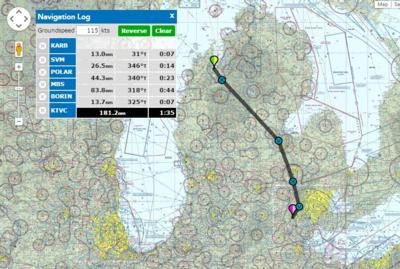
The latest update offered by iFlightPlanner includes a resource to get a quick look at a route and the weather along the way.  The freely accessible Aviation Charts resource available at iFlightPlanner.com/AviationCharts includes the complete set of U.S. Sectional, TAC and IFR Low/High Enroute Charts in the familiar Google Maps interface, updated every 28-days with data direct from the FAA.

It includes the same Map Layers menu used in our Flight Planning Wizard to allow you to overlay hi-resolution RADAR and satellite imagery, as well as fuel prices, enroute conditions, graphical AIRMETs, SIGMETs, and features interactive layers for all Special Use Airspace (SUA). You can even share links to routes with your fellow pilots via email or your favorite social media outlet.

Beginning on October 1, 2015, the FAA will implement flight plan filing for all civil aircraft exclusively under the format used by the International Civil Aviation Organization (ICAO). These flight plans contain specific information relating to the proposed flight of an aircraft and controllers use them to provide air traffic services based on the capabilities of each aircraft.

The iFlightPlanner Crew has produced a QuickTip that will show you how to easily update your aircraft profiles and enjoy a seamless transition to the new ICAO flight plan format when creating and filing flight plans with iFlightPlanner.

The company said in its most recent newsletter that it will be attending Sun 'n Fun with some "exciting new features to share," including a new version for iPad.

(Image provided by iFlightPlanner)

FMI: www.iflightplanner.com

Advertisement

More News

Unfortunate... ANN/SportPlane Resource Guide Adds To Cautionary Advisories

The Industry Continues to be Rocked By Some Questionable Operations Recent investigations and a great deal of data has resulted in ANN’s SportPlane Resource Guide’s rep>[...]

ANN FAQ: Turn On Post Notifications

Make Sure You NEVER Miss A New Story From Aero-News Network Do you ever feel like you never see posts from a certain person or page on Facebook or Instagram? Here’s how you c>[...]

ANN's Daily Aero-Term (04.29.24): Visual Approach Slope Indicator (VASI)

Visual Approach Slope Indicator (VASI) An airport lighting facility providing vertical visual approach slope guidance to aircraft during approach to landing by radiating a directio>[...]

ANN's Daily Aero-Term (04.28.24): Airport Marking Aids

Airport Marking Aids Markings used on runway and taxiway surfaces to identify a specific runway, a runway threshold, a centerline, a hold line, etc. A runway should be marked in ac>[...]

ANN's Daily Aero-Linx (04.28.24)

Aero Linx: The Skyhawk Association The Skyhawk Association is a non-profit organization founded by former Skyhawk Pilots which is open to anyone with an affinity for the A-4 Skyhaw>[...]

blog comments powered by Disqus


Advertisement

Advertisement

Podcasts

Advertisement

© 2007 - 2024 Web Development & Design by Pauli Systems, LC