NASA Tracking Three Active Tropical Cyclones in the Atlantic | Aero-News Network
Aero-News Network
RSS icon RSS feed
podcast icon MP3 podcast
Subscribe Aero-News e-mail Newsletter Subscribe

Airborne Unlimited -- Most Recent Daily Episodes

Episode Date

Airborne-Monday

Airborne-Tuesday

Airborne-Wednesday Airborne-Thursday

Airborne-Friday

Airborne On YouTube

Airborne-Unlimited-04.29.24

Airborne-Unlimited-04.23.24

Airborne-Unlimited-04.24.24 Airborne-FltTraining-04.25.24

Airborne-Unlimited-04.26.24

Fri, Sep 28, 2007

NASA Tracking Three Active Tropical Cyclones in the Atlantic

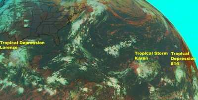
The fourteenth tropical depression of the Atlantic Ocean hurricane season formed in the far eastern Atlantic Ocean today, Friday, Sept. 28th, bringing three active storms in the Atlantic in one week.

Hurricane Lorenzo just made landfall in eastern Mexico, and tropical depression Karen is fizzling in the central Atlantic.

At 11:00 a.m. EDT on Sept. 28, Tropical Depression #14 (TD#14) was located near 14.1 degrees north latitude and 26.5 degrees west longitude, or about 210 miles southwest of Africa's Cape Verde Islands.

The depression is moving toward the west near 7 mph. This general motion should continue today with a gradual turn to the northwest on Saturday, Sept. 29. TD#14's maximum sustained winds are near 35 mph with higher gusts. Some strengthening is possible during the next 24 hours. TD#14's minimum central pressure is 1008 millibars.

The image, above, was created from data from the Geostationary Operational Environmental Satellite (GOES-12), which is operated by the National Oceanic and Atmospheric Administration. It was created by NASA's GOES Project, located at NASA's Goddard Space Flight Center, Greenbelt, Md. It shows all three tropical cyclones. Tropical Depression Lorenzo now over land in south-east Mexico, Tropical Storm Karen in the central Atlantic Ocean, and Tropical Depression #14 to the far right, in the far eastern Atlantic. Credit: Rob Gutro, Goddard Space Flight Center

FMI: www.nasa.gov

Advertisement

More News

ANN's Daily Aero-Term (04.28.24): Airport Marking Aids

Airport Marking Aids Markings used on runway and taxiway surfaces to identify a specific runway, a runway threshold, a centerline, a hold line, etc. A runway should be marked in ac>[...]

Aero-News: Quote of the Day (04.28.24)

"It is extremely difficult, if not impossible, for manned aircraft to see a drone while conducting crop-enhancing and other aerial applications at low altitudes and high speeds. We>[...]

ANN's Daily Aero-Linx (04.28.24)

Aero Linx: The Skyhawk Association The Skyhawk Association is a non-profit organization founded by former Skyhawk Pilots which is open to anyone with an affinity for the A-4 Skyhaw>[...]

Aero-News: Quote of the Day (04.29.24)

“The T-54A benefits from an active Beechcraft King Air assembly line in Wichita, Kansas, where all required METS avionics and interior modifications are installed on the line>[...]

ANN's Daily Aero-Linx (04.29.24)

Aero Linx: Aerostar Owners Association The Association offers the Aerostar Owner a unique opportunity to tap an invaluable source of information concerning the care and feeding of >[...]

blog comments powered by Disqus


Advertisement

Advertisement

Podcasts

Advertisement

© 2007 - 2024 Web Development & Design by Pauli Systems, LC